Search: milwaukee
Filter: Year of 1800-1899
Search: milwaukee
Filter: Year of 1800-1899
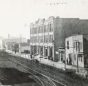
| Date: | 1870 |
|---|---|
| Description: | Buildings along Wisconsin Avenue lining a wide dirt road. |

| Date: | 06 18 1873 |
|---|---|
| Description: | Front page of the inaugural issue of Milwaukee German language newspaper Germania. |

| Date: | 1894 |
|---|---|
| Description: | Advertising card for the Milwaukee Harvester Company featuring an illustration of a little girl holding a small bouquet of wildflowers. |

| Date: | 1849 |
|---|---|
| Description: | A hand-drawn map of showing the two proposed routes from the Milwaukee River to the Moody’s Lime Quarry at Milwaukee, Wisconsin. The map includes the route... |
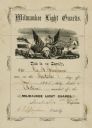
| Date: | 06 30 1855 |
|---|---|
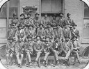
| Description: | Certificate of appointment for George B. Bingham as 1st Lieutenant, Milwaukee Light Guards. |

| Date: | 1894 |
|---|---|
| Description: | Sanborn map of a portion of Milwaukee, including St. Clair and Bishop and Potter Avenues. There is an inset for the South Side Wood Working Co. |
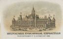
| Date: | 1886 |
|---|---|
| Description: | Print advertising the Milwaukee Industrial Exposition. View of building with flags flying from almost every peak on the the roof. Pedestrians and horse-dra... |
| Date: | 06 1884 |
|---|---|
| Description: | Document recording the case and ruling in favor of Samuel Boynton in the case brought by Clarissa Wood regarding the sale of the Eagle diamond. |

| Date: | 1871-03-28 |
|---|---|
| County: | Milwaukee |
| City: | Milwaukee |

| Date: | 06 1837 |
|---|---|
| Description: | Pen-and-ink on paper. Shows riverside property west of the Milwaukee River. Inscribed by several early Milwaukee settlers, including Henry W. Cleveland, Cy... |

| Date: | 1853 |
|---|---|
| Description: | Plan no. 3. Scale 2000 feet to one inch. |
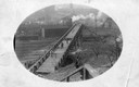
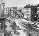
| Date: | 1895 |
|---|---|
| Description: | Men walking across a bridge over railroad tracks. |

| Date: | 1862 |
|---|---|
| Description: | Drawn the second year of the Civil War, this 1862 map of Milwaukee shows post offices, light houses, beacon lights, county buildings, elevator warehouses, ... |
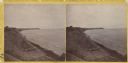
| Date: | 1870 |
|---|---|
| Description: | Stereograph; looking north from the end of Oneida Street along shoreline. |
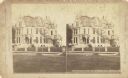
| Date: | 1891 |
|---|---|
| Description: | Stereograph of the home of Charles Ray, 88 Prospect Street. |
If you didn't find the material you searched for, our Library Reference Staff can help.
Call our reference desk at 608-264-6535 or email us at: