 Search: mines
Search: mining
Filter: Categories of Wisconsin Historical Images
Filter: Type of Map or Atlas
Search: mines
Search: mining
Filter: Categories of Wisconsin Historical Images
Filter: Type of Map or Atlas

| Date: | 1829 |
|---|---|
| Description: | Map of lead mines operating in Wisconsin. |

| Date: | 1829 |
|---|---|
| Description: | Cincinnati, Ohio, Ebr. Martin, engraver. |

| Date: | 11 1905 |
|---|---|
| Description: | Sanborn map of Hurley including mining features. |

| Date: | 1800 |
|---|---|
| Description: | Map of the United States. It shows the states, including Tennessee, cities, towns, Native American land, mountains, lakes, and rivers. Lead mines appear ju... |

| Date: | 1850 |
|---|---|
| Description: | Lithograph of a map drawn to indicate a mine on land owned by Mineral Point Mining Co. in the lead region of southwestern Wisconsin. |

| Date: | 02 1898 |
|---|---|
| Description: | Sanborn map of Hurley featuring the Montreal Mining Company. |

| Date: | 1829 |
|---|---|
| Description: | Photoprint of Crawford County lead district map. |

| Date: | 1920 |
|---|---|
| Description: | An ink on tracing paper, hand-drawn map that shows lead mines, the boundary of the lead bearing strata, and the military road in Lafayette, Grant, Iowa, an... |

| Date: | 1858 |
|---|---|
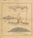
| Description: | This 1858 map shows mine shafts, lead veins, and topography on the property of the New Diggings and Shullsburg Mining Company in Section 5 of Township 1 N.... |

| Date: | 1888 |
|---|---|
| Description: | This is a reproduction of a map originally published in 1829 by R.W. Chandler, a pioneer settler of Galena. It is based on an earlier map by surveyor Luciu... |
| Date: | |
|---|---|
| Description: | This map, based on an 1858 survey, shows the lead vein and the Western Wisconsin Mining Company's mine shafts in a section in the Town of New Diggings, Laf... |
| Date: | 1881 |
|---|---|
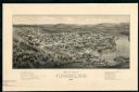
| Description: | The county and city of Florence were named for Florence Hulst, the wife of an early settler. This view illustrates the two industries, mining and lumbering... |

| Date: | 1805 |
|---|---|
| Description: | Map of the United States. It shows the states, cities, towns, Native American land, mountains, lakes, and rivers. Tennessee, Kentucky, and Ohio are labeled... |

| Date: | 1858 |
|---|---|
| Description: | This map of Wisconsin and Minnesota shows proposed railroads, copper mines, marshes, villages, mills, reefs, notes about shorelines, and references to mini... |

| Date: | 1985 |
|---|---|
| Description: | This map shows mining, White River, Silver Creek, Bad River, Agogic Lake, Chequamegon Bay, smaller lakes, the Bad River Indian Reservation, and communities... |

| Date: | 1887 |
|---|---|
| Description: | This map shows mining properties in the Gogebic Range between Atkins Lake, in Sawyer County, Wisconsin, on the west and Lake Gogebic, Michigan, on the east... |

| Date: | 1890 |
|---|---|
| Description: | This late 19th century map shows mining companies' lands and miscellaneous properties in the towns of Cady and Springfield in southeastern Saint Croix Coun... |

| Date: | 1720 |
|---|---|
| Description: | Map of North America from from the Rio Grande to the Atlantic Ocean, showing boundaries, the colonies, cities, settlements, mines, forts, Native American l... |

| Date: | 1969 |
|---|---|
| Description: | This map shows ghost towns, Indian reservations, lakes, railroads, and rivers. Ghost towns are numbered and listed in a corresponding index. |
If you didn't find the material you searched for, our Library Reference Staff can help.
Call our reference desk at 608-264-6535 or email us at:
