 Search: mounds
Filter: Categories of Wisconsin Historical Images
Filter: County of Dane
Filter: Creator Name of Unknown
Search: mounds
Filter: Categories of Wisconsin Historical Images
Filter: County of Dane
Filter: Creator Name of Unknown

| Date: | 07 1838 |
|---|---|
| Description: | A map diagram of Indian effigy mounds seven miles east of Blue Mounds in the Wisconsin Territory. |

| Date: | |
|---|---|
| Description: | Photographic postcard of the view to the west from the top of Blue Mounds, in Blue Mounds State Park. Handwritten is "Platteville Mounds, 45 miles" with an... |

| Date: | |
|---|---|
| Description: | Photographic postcard of the northwest view of Blue Mounds. Text below in a white box reads "N.W. View of Blue Mounds, Wis. Elevation 1760 ft." |
| Date: | |
|---|---|
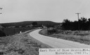
| Description: | View of rural Blue Mounds, with a two-lane, paved road. The caption at the bottom reads: "East View of Blue Mounds, Wis. Elevation, 1760 ft.". |
| Date: | |
|---|---|
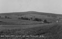
| Description: | View of farmland near Blue Mounds, with possibly property markers horizontal, across the center, and some distant farm houses and a barn. Caption reads: "B... |

| Date: | |
|---|---|
| Description: | Photographic postcard of an old Indian trail marker, a twisted tree, as seen on top of Blue Mounds. Text below reads: "'Old Indian Trail Marker' Top of Blu... |

| Date: | |
|---|---|
| Description: | Photographic postcard of the view towards Madison from the top of Blue Mounds. Handwritten on the card is "State Capitol, 25 miles" with an arrow. Text bel... |
| Date: | 1910 |
|---|---|
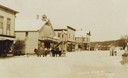
| Description: | View of a main street during the winter. One horse is covered with a horse blanket. Caption reads: "Winter Scene at Blue Mounds Wis." |
| Date: | |
|---|---|
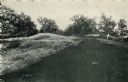
| Description: | A row of conical mounds at Morris Park on the west side of Lake Mendota, in or near Governor Nelson State Park. |
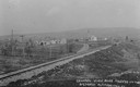
| Date: | 1910 |
|---|---|
| Description: | Distant view of the town, with railroad tracks in foreground. The church is the highest point in the image. "General View. Blue Mounds in the Distance. Alt... |
| Date: | |
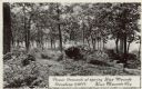
|---|---|
| Description: | Photographic postcard of picnic grounds at a spring in Blue Mounds State Park. The spring is running out of a brick catch basin on the right. A woman weari... |

| Date: | 1969 |
|---|---|
| Description: | A girl is standing high up among a group of stalagmites in the Cave of the Mounds. Another girl is leaning against a railing on the left. |

| Date: | 1925 |
|---|---|
| Description: | A view of Tenpin Alley (rear) active in lead mining days. |

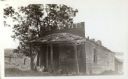
| Date: | 1925 |
|---|---|
| Description: | This building was said to have been an early residence. |
| Date: | |
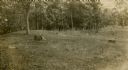
|---|---|
| Description: | A visitor examines conical and effigy mounds at the Williams South mound group near Lake Kegonsa State Park. |
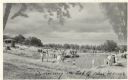
| Date: | |
|---|---|
| Description: | Photographic postcard view of the swimming pool on top of the mounds in Blue Mounds State Park. There are people swimming as well as standing around the si... |
| Date: | 1925 |
|---|---|
| Description: | A view of the front of Tenpin Alley, active in lead mining days. |
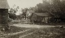
| Date: | 06 1925 |
|---|---|
| Description: | View of three farm buildings - the one in the center is collapsing. |
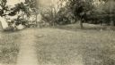
| Date: | |
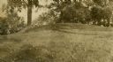
|---|---|
| Description: | A linear burial mound at the T. Lewis Mound group in what is now Indian Mounds Park. |
| Date: | |
|---|---|
| Description: | Oval burial mound at the T. Lewis Mound group in what is now Indian Mounds Park. |
If you didn't find the material you searched for, our Library Reference Staff can help.
Call our reference desk at 608-264-6535 or email us at: