 Search: mounds
Filter: Categories of Wisconsin Historical Images
Filter: County of Grant
Search: mounds
Filter: Categories of Wisconsin Historical Images
Filter: County of Grant

| Date: | 11 03 1903 |
|---|---|
| Description: | A drawing of a group of burial mounds in Linden Valley. Text on back reads: "These mounds lie at the narrow mouth of Linden Valley on the east side of the ... |
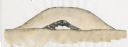
| Date: | 2009 |
|---|---|
| Description: | Watercolor of a Native American burial site. Reconstructed stratigraphy and cross-section representative of conical mounds at the Raisbeck Mound group. |

| Date: | 1925 |
|---|---|
| Description: | View across field towards large mounds of raw material at National Zinc Separating Company plant. Industrial buildings are in the background. |

| Date: | 1925 |
|---|---|
| Description: | View down railroad tracks towards large mounds of raw material at National Zinc Separating Company plant. Industrial buildings and a railroad car and an au... |

| Date: | 1920 |
|---|---|
| Description: | A map of the Nelson-Dewey State Park at the confluence of the Mississippi and Wisconsin rivers, showing the topographical features of the area, as well as ... |

| Date: | 1920 |
|---|---|
| Description: | This 1920 map actually depicts present-day Wyalusing State Park at the confluence of the Mississippi and Wisconsin rivers in the Town of Wyalusing, Grant C... |

| Date: | 1948 |
|---|---|
| Description: | The John H. Rountree House, built in 1854. According to "The History of Wisconsin" (Vol. I, 1973), "The rise of the settlement at Platte Mounds was indisso... |
If you didn't find the material you searched for, our Library Reference Staff can help.
Call our reference desk at 608-264-6535 or email us at: