 Search: mounds
Filter: Categories of Wisconsin Historical Images
Filter: County of Sauk
Search: mounds
Filter: Categories of Wisconsin Historical Images
Filter: County of Sauk

| Date: | 01 01 1852 |
|---|---|
| Description: | These manuscript maps, drawn by William H. Canfield in 1852, illustrate mounds primarily in Sauk County, Wisconsin, in the towns of Greenfield, La Valle, M... |

| Date: | 1861 |
|---|---|
| Description: | This map shows townships and sections, landownership, roads, railroads, rural residences, schools, churches, and topography. Also included are inset maps o... |

| Date: | 1859 |
|---|---|
| Description: | Shows townships and sections, landownership, roads, railroads, rural residences, schools, churches, and topography. Relief shown by hachures. "From governm... |

| Date: | |
|---|---|
| Description: | Map of Baraboo and its surroundings, showing the ancient mound city, the water power, and thoroughfares, drawn by William H. Canfield. Canfield includes sk... |

| Date: | 1859 |
|---|---|
| Description: | Map featuring various views of buildings and scenes from Sauk County. |
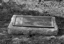
| Date: | 1963 |
|---|---|
| Description: | The marker notes Man Mound Park by the Wisconsin Archeological Society, Sauk County Historical Society and the Landmark Committee, W.F.W.C. |
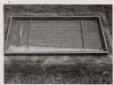
| Date: | 1920 |
|---|---|
| Description: | Historic site marker to commemorate Man Mound and to mark Man Mound Park. The inscription reads "Man Mound Park. Mound located and platted by W.H. Canfield... |
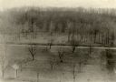
| Date: | |
|---|---|
| Description: | Elevated view of Man Mound outlined in chalk looking south. A road bisects the legs of the effigy mound. A small outbuilding can be seen at left in the for... |
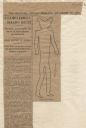
| Date: | 12 28 1906 |
|---|---|
| Description: | Newspaper article about the purchase of land for a park related to Man Mound in Sauk County accompanied by a line drawing of the mound. Article clipped fro... |
If you didn't find the material you searched for, our Library Reference Staff can help.
Call our reference desk at 608-264-6535 or email us at: