 Search: mounds
Filter: Categories of Wisconsin Historical Images
Filter: Subject of botany
Search: mounds
Filter: Categories of Wisconsin Historical Images
Filter: Subject of botany
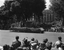
| Date: | 05 29 1948 |
|---|---|
| Description: | Wisconsin Centennial Parade near the Wisconsin State Capitol. The Blue Mounds float depicting Dane County's first settler, Ebenezer Brigham, is coming down... |

| Date: | 07 18 1953 |
|---|---|
| Description: | Unidentified golfer at Koshkonong Mounds Country Club in Fort Atkinson, site of the 31st annual East-Central Wisconsin Golf Association tournament. |
| Date: | |
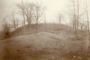
|---|---|
| Description: | Largest platform mound in Trempealeau as seen from the north. |

| Date: | 1920 |
|---|---|
| Description: | This 1920 map actually depicts present-day Wyalusing State Park at the confluence of the Mississippi and Wisconsin rivers in the Town of Wyalusing, Grant C... |

| Date: | 1924 |
|---|---|
| Description: | This pictorial map focuses on the Madison Isthmus, Lake Mendota, Lake Monona, Lake Wingra, and shows points of historical interest, buildings, parks, and I... |

| Date: | 1933 |
|---|---|
| Description: | Blue print and blue line print maps that show local streets, Nakoma Country Club, part of Lake Forest, and part of Lake Wingra. A legend is included that s... |

| Date: | 09 07 2014 |
|---|---|
| Description: | View from the top of a hill looking out to a valley, with clouds in the blue sky. Trees are framing the view, and in the foreground, a woman, the photograp... |
| Date: | |
|---|---|
| Description: | View of Aztalan State Park site when it was called Aztalan Mound Park. |
| Date: | 06 1939 |
|---|---|
| Description: | Elevated view of the tourist attraction Little Norway, situated in an idyllic valley, with the stave church in the center and a small house at right. There... |

| Date: | 1948 |
|---|---|
| Description: | The John H. Rountree House, built in 1854. According to "The History of Wisconsin" (Vol. I, 1973), "The rise of the settlement at Platte Mounds was indisso... |
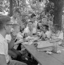
| Date: | 08 1955 |
|---|---|
| Description: | Eight Wisconsin State Journal carrier boys around a picnic table enjoying root beer and apples in the shade of a grove. They are (left to right): Ri... |

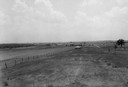
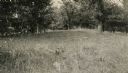
| Date: | |
|---|---|
| Description: | A large burial mound near the south side of Governor Nelson State Park. |

| Date: | 07 13 1955 |
|---|---|
| Description: | Mrs. Charles I. Brigham (left), and her daughter-in-law, Mrs. Charles Brigham, Jr., with her children Mark, Jonathan, and Elizabeth, standing and reading t... |

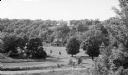
| Date: | 1930 |
|---|---|
| Description: | Poppies are blooming in a large field with a hill in the background. The photographer identifies the hill as a shell mound. The shell mound is likely the l... |
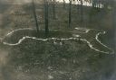
| Date: | 1914 |
|---|---|
| Description: | Deer or rabbit effigy mound outlined with lime (ca. 800-1100 A.D.), at the McConnell mound group. |
| Date: | |
|---|---|
| Description: | An animal effigy burial mound at the Williams South mound group on the north shore of Lake Kegonsa. |
| Date: | |
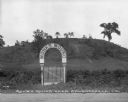
|---|---|
| Description: | View of a gate and sign at Monks Mound, an archaeological site. Caption reads: "Monks Mound near Edwardsville, Ill." |

| Date: | |
|---|---|
| Description: | Tapes and pins mark the locations of Native American corn hills in what is now Governor Nelson State Park. |

| Date: | 06 27 1927 |
|---|---|
| Description: | Aerial view of the effigy mound on Henry Wehmhoff's Riverview Farm. State Trunk Highway 83 runs through the effigy. |

| Date: | |
|---|---|
| Description: | A view of a retail street from the intersection. From the corner of the street, there is a restaurant, hotel, and post office. On the sidewalk, men sit on ... |
If you didn't find the material you searched for, our Library Reference Staff can help.
Call our reference desk at 608-264-6535 or email us at: