 Search: mounds
Filter: Categories of Wisconsin Historical Images
Filter: Subject of botany
Filter: Year of 1900-1999
Search: mounds
Filter: Categories of Wisconsin Historical Images
Filter: Subject of botany
Filter: Year of 1900-1999

| Date: | 1947 |
|---|---|
| Description: | Colorized postcard of the entrance to the Cave of the Mounds. A curved sign sits on two square stone pillars. The sign reads "Welcome, Cave of the Mounds, ... |

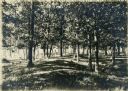
| Date: | 07 31 1960 |
|---|---|
| Description: | Landscape view of willow trees in the Valley of the Mounds Creek, along Highway F. |
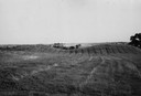
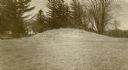
| Date: | 1945 |
|---|---|
| Description: | Field with contours, and two mounds. |
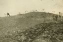
| Date: | 08 1905 |
|---|---|
| Description: | A visitor takes in the sight of three linear burial mounds at the Sure-Johnson mound group south of McFarland, Wisconsin. |

| Date: | 1948 |
|---|---|
| Description: | Colorized postcard of a Norwegian building at Little Norway in Blue Mounds. Built in Norway by the Norwegian Government, for the Columbian Exposition, Chic... |

| Date: | 1920 |
|---|---|
| Description: | Two cottages at Burgy Mounds on Lake Koshkonong. |
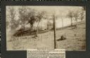
| Date: | 1905 |
|---|---|
| Description: | Two of a series of three large platform mounds on the top of a high hill, overlooking the Mississippi and Black River valleys. Two young children are seate... |

| Date: | 06 20 1950 |
|---|---|
| Description: | Photographic postcard of the Gate House at Little Norway. Text below reads "The Gate House, Little Norway, Blue Mounds, Wisconsin." |
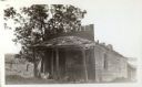
| Date: | 1925 |
|---|---|
| Description: | A view of the front of Tenpin Alley, active in lead mining days. |
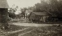
| Date: | 06 1925 |
|---|---|
| Description: | View of three farm buildings - the one in the center is collapsing. |

| Date: | 05 05 1939 |
|---|---|
| Description: | Charles E. Brown poses near a historic tablet marking one of a row of conical burial mounds on the Park and Pleasure drive on the north shore of Lake Wingr... |

| Date: | 1910 |
|---|---|
| Description: | A sightseeing party wanders among cows and Native American burial mounds near the popular picnic area at Merrill Springs, on the south shore of Lake Mendot... |
| Date: | 1913 |
|---|---|
| Description: | One of the large burial mounds of the Outlet mound group on the former Hoyt property at the foot of Lake Monona. |
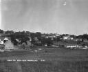
| Date: | 1930 |
|---|---|
| Description: | Bird's-eye view town. There are barns, homes, a church's steeple and a lumberyard. |
| Date: | 1909 |
|---|---|
| Description: | A horse grazes near Native American burial mounds on the Dividing Ridge, a recessional moraine, between Lakes Monona and Wingra in Madison, Wisconsin. The ... |

| Date: | 1915 |
|---|---|
| Description: | A row of conical burial mounds adjoins the Park and Pleasure Drive on the north shore of Lake Wingra (now Edgewood Drive, at the south edge of Edgewood Col... |
| Date: | 1914 |
|---|---|
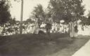
| Description: | Ceremony for erecting tablets on the Observatory Hill Mounds performed by University of Wisconsin summer session students. |

| Date: | 10 1911 |
|---|---|
| Description: | This map shows lot numbers, building lines, roads, trees, and Indian mounds. Relief is shown by contours. Includes manuscript annotations marking parks. |

| Date: | 07 31 1960 |
|---|---|
| Description: | An abandoned threshing machine rests in a rural field. |
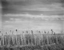
| Date: | 10 1966 |
|---|---|
| Description: | Tall grass grows at the roadside edge of a flat field. |
If you didn't find the material you searched for, our Library Reference Staff can help.
Call our reference desk at 608-264-6535 or email us at: