Search: mounds
Filter: Categories of Wisconsin Historical Images
Filter: Subject of dwellings
Search: mounds
Filter: Categories of Wisconsin Historical Images
Filter: Subject of dwellings

| Date: | |
|---|---|
| Description: | Map of prehistoric mounds near the Big Kanawha River. |
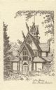
| Date: | |
|---|---|
| Description: | Line drawing of a Norwegian building at Little Norway. Text below reads "Little Norway, Blue Mounds, Wisconsin." |

| Date: | |
|---|---|
| Description: | Ink and watercolor of prehistoric mounds near the mouth of Haigs Creek and the Scioto River. |

| Date: | 1948 |
|---|---|
| Description: | Colorized postcard of a Norwegian building at Little Norway in Blue Mounds. Built in Norway by the Norwegian Government, for the Columbian Exposition, Chic... |

| Date: | 1925 |
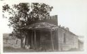
|---|---|
| Description: | A view of Tenpin Alley (rear) active in lead mining days. |

| Date: | 1925 |
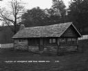
|---|---|
| Description: | This building was said to have been an early residence. |

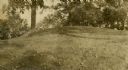
| Date: | 1920 |
|---|---|
| Description: | Two cottages at Burgy Mounds on Lake Koshkonong. |

| Date: | 06 20 1950 |
|---|---|
| Description: | Photographic postcard of the Gate House at Little Norway. Text below reads "The Gate House, Little Norway, Blue Mounds, Wisconsin." |
| Date: | 1925 |
|---|---|
| Description: | A view of the front of Tenpin Alley, active in lead mining days. |

| Date: | 1867 |
|---|---|
| Description: | This 1867 manuscript map by Increase Lapham shows the topography and geology of the Blue Mounds region in the Town of Brigham in Iowa County and the towns ... |
| Date: | |
|---|---|
| Description: | Oval burial mound at the T. Lewis Mound group in what is now Indian Mounds Park. |
| Date: | |
|---|---|
| Description: | A linear burial mound at the T. Lewis Mound group in what is now Indian Mounds Park. |
| Date: | |
|---|---|
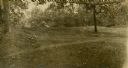
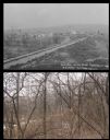
| Description: | A vintage view and a modern view of the same area in Blue Mounds, presented as a pair. The vintage view shows a road leading into the town. The modern view... |
| Date: | 08 30 1876 |
|---|---|
| Description: | Interior view of Blue Mounds Church. Built in 1868, the church was originally named the Norsk Evangelisk Kirke. |

| Date: | |
|---|---|
| Description: | View looking uphill towards three platform mounds. The numbers 1, 2, and 3 are written on the photograph in ink. Part of the way up the hill are a small sh... |
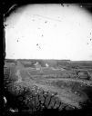
| Date: | 1873 |
|---|---|
| Description: | View down a rocky rural lane near West Blue Mounds. Zigzag stake and rider split-rail fencing enclose a farmstead, which includes a barn, a frame house, ha... |
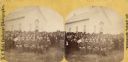
| Date: | 08 30 1876 |
|---|---|
| Description: | "View of the ministers present" from the "Dedication of Blue Mounds Church" section of Dahl's 1877 "Catalogue of Stereoscopic Views." The congregation of t... |

| Date: | 1903 |
|---|---|
| Description: | This maps shows what may be Ho Chunk Native American burial mounds. Also noted on the map is the Fox River, the Doty homestead, stockade embankment, the We... |
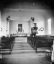
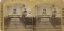
| Date: | 08 30 1876 |
|---|---|
| Description: | "View of the interior of the church" from the "Dedication of Blue Mounds Church" section of Dahl's 1877 "Catalogue of Stereoscopic Views." The church was d... |
If you didn't find the material you searched for, our Library Reference Staff can help.
Call our reference desk at 608-264-6535 or email us at: