 Search: mounds
Filter: Categories of Wisconsin Historical Images
Filter: Subject of hills
Search: mounds
Filter: Categories of Wisconsin Historical Images
Filter: Subject of hills

| Date: | |
|---|---|
| Description: | Photographic postcard of the view to the west from the top of Blue Mounds, in Blue Mounds State Park. Handwritten is "Platteville Mounds, 45 miles" with an... |

| Date: | |
|---|---|
| Description: | Photographic postcard of the northwest view of Blue Mounds. Text below in a white box reads "N.W. View of Blue Mounds, Wis. Elevation 1760 ft." |
| Date: | |
|---|---|
| Description: | View of farmland near Blue Mounds, with possibly property markers horizontal, across the center, and some distant farm houses and a barn. Caption reads: "B... |

| Date: | |
|---|---|
| Description: | Photographic postcard of the view towards Madison from the top of Blue Mounds. Handwritten on the card is "State Capitol, 25 miles" with an arrow. Text bel... |

| Date: | |
|---|---|
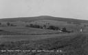
| Description: | View looking down hill of several buildings. More hills are in the far background. Caption reads: "Blue Mounds at a Distance, Altitude 1760 FT." |
| Date: | 04 25 2012 |
|---|---|
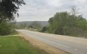
| Description: | A view of the approach to the Village of Blue Mounds from the cemetery. |
| Date: | |
|---|---|
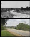
| Description: | A vintage view and a modern view of a road to Blue Mounds, presented as a pair. |
| Date: | 1910 |
|---|---|
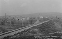
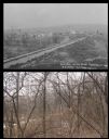
| Description: | Distant view of the town, with railroad tracks in foreground. The church is the highest point in the image. "General View. Blue Mounds in the Distance. Alt... |

| Date: | 1844 |
|---|---|
| Description: | Part of a series of local maps, showing a number of burial mounds in the shape of animals near Madison, Wisconsin along military road. The maps also show d... |
| Date: | 1905 |
|---|---|
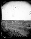
| Description: | Two of a series of three large platform mounds on the top of a high hill, overlooking the Mississippi and Black River valleys. Two young children are seate... |

| Date: | 11 03 1903 |
|---|---|
| Description: | A drawing of a group of burial mounds in Linden Valley. Text on back reads: "These mounds lie at the narrow mouth of Linden Valley on the east side of the ... |
| Date: | |
|---|---|
| Description: | A vintage view and a modern view of the same area in Blue Mounds, presented as a pair. The vintage view shows a road leading into the town. The modern view... |

| Date: | |
|---|---|
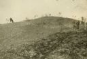
| Description: | View looking uphill towards three platform mounds. The numbers 1, 2, and 3 are written on the photograph in ink. Part of the way up the hill are a small sh... |

| Date: | 1851 |
|---|---|
| Description: | Map of a portion of Merton including the Bark River, a mill, Fort Hill, and Indian mounds. |
| Date: | 1873 |
|---|---|
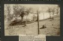
| Description: | View down a rocky rural lane near West Blue Mounds. Zigzag stake and rider split-rail fencing enclose a farmstead, which includes a barn, a frame house, ha... |
| Date: | 1909 |
|---|---|
| Description: | A horse grazes near Native American burial mounds on the Dividing Ridge, a recessional moraine, between Lakes Monona and Wingra in Madison, Wisconsin. The ... |
| Date: | 1914 |
|---|---|
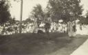
| Description: | Ceremony for erecting tablets on the Observatory Hill Mounds performed by University of Wisconsin summer session students. |

| Date: | 1930 |
|---|---|
| Description: | Remains of the racetrack on the top of Blue Mound. |

| Date: | |
|---|---|
| Description: | View of the village from the railroad tracks. There is a church among the cluster of homes. |

| Date: | 1864 |
|---|---|
| Description: | This map is pen and pencil on paper and shows a profile of the Blue Mound and East Blue Mound. |
If you didn't find the material you searched for, our Library Reference Staff can help.
Call our reference desk at 608-264-6535 or email us at: