 Search: mounds
Filter: Categories of Wisconsin Historical Images
Filter: Subject of industries
Search: mounds
Filter: Categories of Wisconsin Historical Images
Filter: Subject of industries

| Date: | 1867 |
|---|---|
| Description: | This 1867 manuscript map by Increase Lapham shows the topography and geology of the Blue Mounds region in the Town of Brigham in Iowa County and the towns ... |
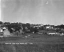
| Date: | 1930 |
|---|---|
| Description: | Bird's-eye view town. There are barns, homes, a church's steeple and a lumberyard. |

| Date: | 1866 |
|---|---|
| Description: | A map of Lafayette County, Wisconsin, showing the townships and ranges, sections, towns, villages, stream and rivers, mounds, mineral deposits and the Mine... |

| Date: | 1864 |
|---|---|
| Description: | This map is pen and watercolor on paper and shows profile and geological formation of Blue Mound and location of Arnold’s Hotel and Brigham Lead Mines. |
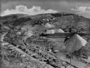
| Date: | 1920 |
|---|---|
| Description: | Elevated view of a mining community, including numerous houses, mining structures, and large mounds of gravel material. |

| Date: | 04 21 1911 |
|---|---|
| Description: | Group of men and a young boy breaking hemp at the Brigham farm. |

| Date: | 1925 |
|---|---|
| Description: | View across field towards large mounds of raw material at National Zinc Separating Company plant. Industrial buildings are in the background. |
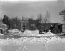
| Date: | 12 20 1947 |
|---|---|
| Description: | Exterior view of the new building for radio station WIBA under construction. There are piles of snow and building supplies around an entrance. |

| Date: | 05 30 1964 |
|---|---|
| Description: | Landscape view from field of a rolling countryside. A small cheese factory resides on a slope, with a tree, a windmill, two cars and a tractor near an outb... |

| Date: | 1925 |
|---|---|
| Description: | View down railroad tracks towards large mounds of raw material at National Zinc Separating Company plant. Industrial buildings and a railroad car and an au... |

| Date: | 1955 |
|---|---|
| Description: | Slightly elevated view of a truck, crane and other digging equipment being used to dig up ground near a field. Several mounds of dirt are behind the machin... |
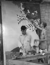
| Date: | 06 25 1948 |
|---|---|
| Description: | Edwin Morgan, at bench, and James Price, shirtless with cigarette in his mouth, are painting scenery for the Crater Players production of "The Drunkard". |

| Date: | 1872 |
|---|---|
| Description: | This map, which includes eastern Iowa, northern Illinois and a portion of Michigan's Upper peninsula, shows the township survey grid and identifies countie... |

| Date: | 1864 |
|---|---|
| Description: | This map shows locations of quarries, sink holes, creeks, springs, rivers, houses, forts, and roads. Annotations in pencil read: "Is the top of the mound l... |

| Date: | 1864 |
|---|---|
| Description: | This map is pen and watercolor on paper and shows a profile and the geological formation of Blue Mound. Also shown is the location of Arnold's Hotel and Br... |

| Date: | 1864 |
|---|---|
| Description: | This map shows locations of quarries, sink holes, creeks, springs, rivers, houses, forts, and roads. |

| Date: | 1864 |
|---|---|
| Description: | This map shows locations of quarries, sink holes, creeks, springs, rivers, houses, forts, and roads. The upper right corner and right margin includes anno... |

| Date: | 1864 |
|---|---|
| Description: | Map showing locations of quarries, sink holes, creeks, springs, rivers, houses, forts, and roads. The map appears to have been drawn on to of a plat map of... |

| Date: | 05 23 1958 |
|---|---|
| Description: | Construction begins on Spring Harbor School, 1110 Spring Harbor Drive just north of University Avenue. The building was designed by Kaeser and McLeod Archi... |
If you didn't find the material you searched for, our Library Reference Staff can help.
Call our reference desk at 608-264-6535 or email us at: