Search: mounds
Filter: Categories of Wisconsin Historical Images
Filter: Subject of land use
Search: mounds
Filter: Categories of Wisconsin Historical Images
Filter: Subject of land use

| Date: | 02 2014 |
|---|---|
| Description: | View across street towards the historic Blue Mounds Opera House. Exterior stairs lead to porches on the ground and second floor. A small metal fence surrou... |

| Date: | 1903 |
|---|---|
| Description: | This maps shows what may be Ho Chunk Native American burial mounds. Also noted on the map is the Fox River, the Doty homestead, stockade embankment, the We... |

| Date: | 10 1911 |
|---|---|
| Description: | This map shows lot numbers, building lines, roads, trees, and Indian mounds. Relief is shown by contours. Includes manuscript annotations marking parks. |

| Date: | 1930 |
|---|---|
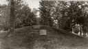
| Description: | Remains of the racetrack on the top of Blue Mound. |

| Date: | 07 31 1960 |
|---|---|
| Description: | An abandoned threshing machine rests in a rural field. |
| Date: | 10 1966 |
|---|---|
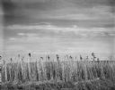
| Description: | Tall grass grows at the roadside edge of a flat field. |
| Date: | 1930 |
|---|---|
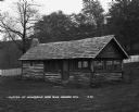
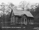
| Description: | Exterior of a cabin in Nissedahle (Little Norway). |
| Date: | |
|---|---|
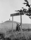
| Description: | Little girl under the "Aztalan Mound Park" sign, in a field. Another person stands in the background on one of the mounds. |

| Date: | |
|---|---|
| Description: | Wisconsin Memorial Hospital with a key to buildings in the upper left. Indian mounds are marked on the site. Arthur Peabody was the state architect for th... |

| Date: | |
|---|---|
| Description: | View of the village from the railroad tracks. There is a church among the cluster of homes. |

| Date: | |
|---|---|
| Description: | Map showing Indian mounds in Milwaukee's Second Ward from a sketch made by Increase Lapham in 1836. Streets shown on the map include 6th Street, 5th Street... |

| Date: | 1864 |
|---|---|
| Description: | This map is pen and pencil on paper and shows a profile of the Blue Mound and East Blue Mound. |

| Date: | 1948 |
|---|---|
| Description: | Colorized postcard of a bedroom with a built-in bed with bed curtains, two chairs and a table. A large painting decorates the wall. Text below reads "Littl... |

| Date: | 1864 |
|---|---|
| Description: | This map is pen and watercolor on paper and shows a profile and geological sections of the Blue Mounds, Hollow Run, Bogies Hollow Run, Bear Creek, East Bre... |

| Date: | 06 1973 |
|---|---|
| Description: | Fifth-graders from Mayville Public School celebrate the end of the school year by running down the earthen mounds at Aztalan State Park. Teachers on the tr... |

| Date: | 1864 |
|---|---|
| Description: | This map is pen and watercolor on paper and shows profile and geological formation of Blue Mound and location of Arnold’s Hotel and Brigham Lead Mines. |
| Date: | 1871 |
|---|---|
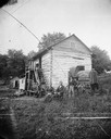
| Description: | Andrew Dahl's wagon is on the side of a two-story log house in Blue Mounds. On one side of the wagon cover is "A.L. Dahl Landscape Photographer." On the ba... |
| Date: | 1948 |
|---|---|
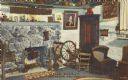
| Description: | Colorized postcard of the main living area of a Norwegian dwelling at Little Norway showing a fireplace, cradle and spinning wheel. Pictures and household ... |
If you didn't find the material you searched for, our Library Reference Staff can help.
Call our reference desk at 608-264-6535 or email us at: