 Search: mounds
Filter: Categories of Wisconsin Historical Images
Filter: Subject of land use
Search: mounds
Filter: Categories of Wisconsin Historical Images
Filter: Subject of land use
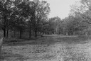
| Date: | 1930 |
|---|---|
| Description: | View of a wide path through trees in the spring or summer. |

| Date: | 1930 |
|---|---|
| Description: | Aerial view of the town, including the central business district. |
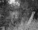
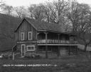
| Date: | 09 01 1963 |
|---|---|
| Description: | A view of an abandoned log cabin obscured by plants and trees. |
| Date: | 1948 |
|---|---|
| Description: | Colorized postcard of a scene at Little Norway. A man sits on a wagon chassis. He is wearing an ethnic costume. Various buildings are visible surrounded by... |

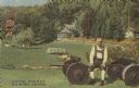
| Date: | 07 20 1950 |
|---|---|
| Description: | Photographic postcard of a scene at Little Norway. A log building stands to the left and the chassis of a wagon to the right. Text below reads: "Scene at L... |

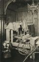
| Date: | 07 20 1950 |
|---|---|
| Description: | Photographic postcard of the main living area of a Norwegian dwelling at Little Norway showing a cradle, chairs, trunks, dresser and a built-in bed with cu... |

| Date: | |
|---|---|
| Description: | Color postcard of a dining room in a dwelling at Little Norway. |

| Date: | 1892 |
|---|---|
| Description: | This map oriented with north to the upper left shows railroads, creeks, post offices, smaller lakes, Lake Mendota, Lake Monona, Lake Wingra, Lake Waubesa, ... |

| Date: | 1931 |
|---|---|
| Description: | This map of south central Wisconsin shows lakes, rivers, cities, villages, highways and roads, railroads, Indian mounds, and points of scenic and historic ... |

| Date: | |
|---|---|
| Description: | Photographic postcard view of one of the Indian mounds at Aztalan State Park. Steps lead up to the top of the mound from the right, and a tall fence is beh... |

| Date: | 1900 |
|---|---|
| Description: | This photocopy map shows marshes, woods, buildings, and selected features including islands, mounds, old Fort Crawford, and "new site for a fort in questio... |
| Date: | 10 07 1914 |
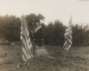
|---|---|
| Description: | Sara (Mrs. Joseph) Mallon (Menominee) of Milwaukee, wearing a sash stands between two American flags behind a memorial that reads, "Indian Mounds: One of s... |

| Date: | |
|---|---|
| Description: | Color postcard of a Norwegian building at Little Norway. Built in Norway by the Norwegian Government, for the Columbian Exposition, Chicago, 1893. |
| Date: | 1920 |
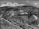
|---|---|
| Description: | Elevated view of a mining community, including numerous houses, mining structures, and large mounds of gravel material. |
| Date: | 1930 |
|---|---|
| Description: | Exterior of a two-story cabin in Nissedahle (Little Norway). There is a cafe on the first floor. |
| Date: | |
|---|---|
| Description: | Black and white postcard of an indoor scene with a loom, spinning wheel, skeiner, garments and two dolls seated in a chair at Little Norway. |

| Date: | 1850 |
|---|---|
| Description: | Map showing Indian mounds and graves as well as ground cover types at Township 8, Range 22. There is an inset diagram of an effigy mound labeled "The Cross... |

| Date: | 1925 |
|---|---|
| Description: | This map shows trails, mounds, villages, corn fields, and contemporary civil townships; some villages and features include both Indian and English place na... |

| Date: | 04 28 2015 |
|---|---|
| Description: | View down a gravel path leading into a forest. The trees are bare of leaves, but the grass is green. A wood marker is at the intersection of a dirt path on... |

| Date: | 12 01 1962 |
|---|---|
| Description: | A farm road between fields in late sunlight, looking towards Mounds Creek in the vicinity of CTH F. |
If you didn't find the material you searched for, our Library Reference Staff can help.
Call our reference desk at 608-264-6535 or email us at: