Search: mounds
Filter: Categories of Wisconsin Historical Images
Filter: Subject of land use
Search: mounds
Filter: Categories of Wisconsin Historical Images
Filter: Subject of land use
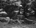
| Date: | 07 31 1960 |
|---|---|
| Description: | A large rock formation in the schoolyard of the Deneen School. A small outbuilding and fence is visible in the background. |

| Date: | 1925 |
|---|---|
| Description: | A view looking up a winding road with rows of utility lines on both sides. The road is partially fenced. |

| Date: | 1962 |
|---|---|
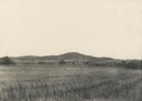
| Description: | Elevated view over wooded farmland valley. In the far distance on top of the hill are farm buildings. |

| Date: | 1919 |
|---|---|
| Description: | Narrow red lines show principal secondary highways. Green circles shows points of historical interest. Green triangles show Indian mounds and Indian villag... |

| Date: | 04 21 1911 |
|---|---|
| Description: | Group of men and a young boy breaking hemp at the Brigham farm. |

| Date: | 1955 |
|---|---|
| Description: | View across field of a dynamite explosion occurring between several mounds of dirt. A digger stands next to the dirt mound on the right. |

| Date: | 1861 |
|---|---|
| Description: | This map shows townships and sections, landownership, roads, railroads, rural residences, schools, churches, and topography. Also included are inset maps o... |
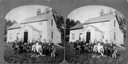
| Date: | 1875 |
|---|---|
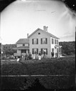
| Description: | A family group of eleven sits around a table with a pitcher and books before the farm house of Knud Gjesma. |

| Date: | 07 31 1960 |
|---|---|
| Description: | View of a tree and mailbox, with a farmhouse behind below road level along a rural highway. There is a hill in the background with trees. |
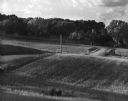
| Date: | 07 1967 |
|---|---|
| Description: | A country road and electrical lines run through a field of oats. On the left is a road, and a farmhouse is in the background on a hill. |

| Date: | 1925 |
|---|---|
| Description: | View across field towards large mounds of raw material at National Zinc Separating Company plant. Industrial buildings are in the background. |

| Date: | 1892 |
|---|---|
| Description: | Topographical map of Madison and surrounding communities which include Lake Mendota, Lake Monona, Lake Waubesa and Lake Kegonsa. The red dots on the map sh... |

| Date: | 1974 |
|---|---|
| Description: | This 1974 map is a reproduction of the original survey maps of the Four Lakes region of Dane County, Wisconsin. It shows sections, lakes, rivers, wetlands,... |

| Date: | 1864 |
|---|---|
| Description: | This map is pen and pencil on paper and shows a profile of the Blue Mound and East Blue Mound. |
| Date: | 1879 |
|---|---|
| Description: | Harold and Gunhild Mickelson with five of their daughters (Bertha Mickelson Bragger and her husband are standing on the right), in Section 23 of the Town o... |

| Date: | 1927 |
|---|---|
| Description: | Blueprint-style map of Frost Woods on the shore of Lake Monona. The map indicates the locations of Indian mounds, an Indian camp, and various plants. There... |

| Date: | 1859 |
|---|---|
| Description: | Shows townships and sections, landownership, roads, railroads, rural residences, schools, churches, and topography. Relief shown by hachures. "From governm... |

| Date: | 1924 |
|---|---|
| Description: | A map of the Madison Township, T7N R9E including Lake Mendota showing the location of Ho Chunk encampments and effigy mounds. |
If you didn't find the material you searched for, our Library Reference Staff can help.
Call our reference desk at 608-264-6535 or email us at: