 Search: mounds
Filter: Categories of Wisconsin Historical Images
Filter: Subject of land use
Search: mounds
Filter: Categories of Wisconsin Historical Images
Filter: Subject of land use

| Date: | |
|---|---|
| Description: | A hand-colored geological cross section of Iowa County and eastern Dane County, Wisconsin, from the Blue Mounds north-northwest to the sandy plain of the W... |

| Date: | 1850 |
|---|---|
| Description: | This 1850 survey by William H. Canfield shows the mounds near Wiegands Bay on the Wisconsin River in the Town of Merrimac, Sauk County, Wisconsin. |

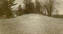
| Date: | |
|---|---|
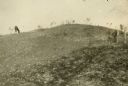
| Description: | View looking uphill towards three platform mounds. The numbers 1, 2, and 3 are written on the photograph in ink. Part of the way up the hill are a small sh... |

| Date: | 2009 |
|---|---|
| Description: | Watercolor of a Native American burial site. Reconstructed stratigraphy and cross-section representative of effigy mounds at the Nitschke Mound group. |

| Date: | 05 05 1939 |
|---|---|
| Description: | Charles E. Brown poses near a historic tablet marking one of a row of conical burial mounds on the Park and Pleasure drive on the north shore of Lake Wingr... |
| Date: | 09 05 1921 |
|---|---|
| Description: | Anna Fox, great-grand niece of Ebenezer Brigham, just after removing the flag unveiling the bronze tablet commemorating Fort Blue Mounds. State historical ... |

| Date: | 1851 |
|---|---|
| Description: | Map of a portion of Merton including the Bark River, a mill, Fort Hill, and Indian mounds. |

| Date: | 2009 |
|---|---|
| Description: | Watercolor of a Native American burial site. Reconstructed stratigraphy and cross-section representative of effigy mounds at the Kratz Creek Mound group. |

| Date: | |
|---|---|
| Description: | View of burial mounds in a park on the edge of a lake. Caption reads: "Indian Burial Grounds in Wakanda Park, Menomonie, Wis." |

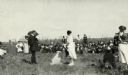
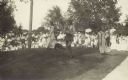
| Date: | 1910 |
|---|---|
| Description: | A sightseeing party wanders among cows and Native American burial mounds near the popular picnic area at Merrill Springs, on the south shore of Lake Mendot... |
| Date: | 1873 |
|---|---|
| Description: | View down a rocky rural lane near West Blue Mounds. Zigzag stake and rider split-rail fencing enclose a farmstead, which includes a barn, a frame house, ha... |
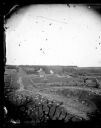
| Date: | 1913 |
|---|---|
| Description: | One of the large burial mounds of the Outlet mound group on the former Hoyt property at the foot of Lake Monona. |

| Date: | 1923 |
|---|---|
| Description: | A man in the distance stands on a mound, which is part of a group of mounds near the Fox River. Many artifacts including arrowheads and human bones have be... |
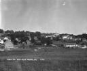
| Date: | 1930 |
|---|---|
| Description: | Bird's-eye view town. There are barns, homes, a church's steeple and a lumberyard. |
| Date: | 1909 |
|---|---|
| Description: | A horse grazes near Native American burial mounds on the Dividing Ridge, a recessional moraine, between Lakes Monona and Wingra in Madison, Wisconsin. The ... |

| Date: | 1915 |
|---|---|
| Description: | A row of conical burial mounds adjoins the Park and Pleasure Drive on the north shore of Lake Wingra (now Edgewood Drive, at the south edge of Edgewood Col... |
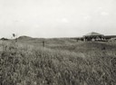
| Date: | 1935 |
|---|---|
| Description: | View of the site when it was known as Aztalan Mound Park or Aztalan Mounds, near Lake Mills. There is a pavilion in the right background. |
| Date: | 1914 |
|---|---|
| Description: | Ceremony for erecting tablets on the Observatory Hill Mounds performed by University of Wisconsin summer session students. |

| Date: | 1866 |
|---|---|
| Description: | A map of Lafayette County, Wisconsin, showing the townships and ranges, sections, towns, villages, stream and rivers, mounds, mineral deposits and the Mine... |

| Date: | 1941 |
|---|---|
| Description: | This pictorial map shows sites related to Indian legends, mounds, and trails in the Chain O' Lakes region in southwestern Waupaca County, Wisconsin. |
If you didn't find the material you searched for, our Library Reference Staff can help.
Call our reference desk at 608-264-6535 or email us at: