 Search: mounds
Filter: Categories of Wisconsin Historical Images
Filter: Subject of land use
Filter: Year of 1800-1899
Search: mounds
Filter: Categories of Wisconsin Historical Images
Filter: Subject of land use
Filter: Year of 1800-1899
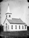
| Date: | 1872 |
|---|---|
| Description: | East Blue Mounds Lutheran Church, built in 1868. The church was formerly the Norsk Evangelisk Lutheranisk Kirke. |

| Date: | 1876 |
|---|---|
| Description: | A sketch map of the procession of Indian mounds on the two ridged field sites in Grant County. |

| Date: | 1800 |
|---|---|
| Description: | This map on two sheets shows a group of ancient mounds near the southeast corner of the city of Beloit and a group of ancient mounds north of Rockton Stati... |

| Date: | 1844 |
|---|---|
| Description: | Part of a series of local maps, showing a number of burial mounds in the shape of animals near Madison, Wisconsin along military road. The maps also show d... |

| Date: | 1800 |
|---|---|
| Description: | An ink on paper map for a plan of mounds in Milwaukee county. The map is situated pointing north. |
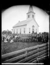
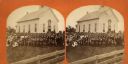
| Date: | 08 30 1876 |
|---|---|
| Description: | The congregation of the East Blue Mounds Lutheran Church and visiting ministers are gathered for the church dedication. The church was formerly Norsk Evang... |

| Date: | 1850 |
|---|---|
| Description: | Diagrams of four effigy mounds surveyed by Increase A. Lapham and W.H. Canfield in 1850. No. 1 is an unidentified animal shape, No. 2 consists of two linea... |
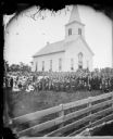
| Date: | 08 30 1876 |
|---|---|
| Description: | The congregation of the East Blue Mounds Lutheran Church and visiting ministers are gathered for the church dedication. The church was formerly Norsk Evang... |
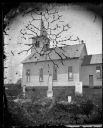
| Date: | 1876 |
|---|---|
| Description: | East Blue Mounds Lutheran Church, formerly Norsk Evangelisk Kirke, built in 1868. The graves of Andreas L. Dahl's mother, Berthe Nelsdatter (Lund) Dahlen, ... |
| Date: | 08 30 1876 |
|---|---|
| Description: | The congregation of the East Blue Mounds Lutheran Church and visiting ministers are gathered for the church dedication. The church was formerly Norsk Evang... |

| Date: | 01 01 1852 |
|---|---|
| Description: | These manuscript maps, drawn by William H. Canfield in 1852, illustrate mounds primarily in Sauk County, Wisconsin, in the towns of Greenfield, La Valle, M... |
| Date: | 1890 |
|---|---|
| Description: | At the Aztalan Indian Mounds a group of people are standing on a hillside in the background. In the foreground are corn shocks. |

| Date: | 1850 |
|---|---|
| Description: | This 1850 survey by William H. Canfield shows the mounds near Wiegands Bay on the Wisconsin River in the Town of Merrimac, Sauk County, Wisconsin. |

| Date: | 1851 |
|---|---|
| Description: | Map of a portion of Merton including the Bark River, a mill, Fort Hill, and Indian mounds. |
| Date: | 1873 |
|---|---|
| Description: | View down a rocky rural lane near West Blue Mounds. Zigzag stake and rider split-rail fencing enclose a farmstead, which includes a barn, a frame house, ha... |

| Date: | 1866 |
|---|---|
| Description: | A map of Lafayette County, Wisconsin, showing the townships and ranges, sections, towns, villages, stream and rivers, mounds, mineral deposits and the Mine... |

| Date: | 1864 |
|---|---|
| Description: | This map is pen and pencil on paper and shows a profile of the Blue Mound and East Blue Mound. |

| Date: | 1864 |
|---|---|
| Description: | This map is pen and watercolor on paper and shows a profile and geological sections of the Blue Mounds, Hollow Run, Bogies Hollow Run, Bear Creek, East Bre... |

| Date: | 1864 |
|---|---|
| Description: | This map is pen and watercolor on paper and shows profile and geological formation of Blue Mound and location of Arnold’s Hotel and Brigham Lead Mines. |
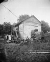
| Date: | 1871 |
|---|---|
| Description: | Andrew Dahl's wagon is on the side of a two-story log house in Blue Mounds. On one side of the wagon cover is "A.L. Dahl Landscape Photographer." On the ba... |
If you didn't find the material you searched for, our Library Reference Staff can help.
Call our reference desk at 608-264-6535 or email us at: