 Search: mounds
Filter: Categories of Wisconsin Historical Images
Filter: Subject of mines and mineral resources
Search: mounds
Filter: Categories of Wisconsin Historical Images
Filter: Subject of mines and mineral resources

| Date: | 1866 |
|---|---|
| Description: | A map of Lafayette County, Wisconsin, showing the townships and ranges, sections, towns, villages, stream and rivers, mounds, mineral deposits and the Mine... |

| Date: | 1864 |
|---|---|
| Description: | This map is pen and watercolor on paper and shows profile and geological formation of Blue Mound and location of Arnold’s Hotel and Brigham Lead Mines. |
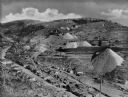
| Date: | 1920 |
|---|---|
| Description: | Elevated view of a mining community, including numerous houses, mining structures, and large mounds of gravel material. |

| Date: | 1925 |
|---|---|
| Description: | View across field towards large mounds of raw material at National Zinc Separating Company plant. Industrial buildings are in the background. |

| Date: | 1925 |
|---|---|
| Description: | View down railroad tracks towards large mounds of raw material at National Zinc Separating Company plant. Industrial buildings and a railroad car and an au... |

| Date: | 1872 |
|---|---|
| Description: | This map, which includes eastern Iowa, northern Illinois and a portion of Michigan's Upper peninsula, shows the township survey grid and identifies countie... |

| Date: | 1864 |
|---|---|
| Description: | This map is pen and watercolor on paper and shows a profile and the geological formation of Blue Mound. Also shown is the location of Arnold's Hotel and Br... |
If you didn't find the material you searched for, our Library Reference Staff can help.
Call our reference desk at 608-264-6535 or email us at: