 Search: mounds
Filter: Categories of Wisconsin Historical Images
Filter: Subject of mounds
Filter: Subject of intellectual life
Search: mounds
Filter: Categories of Wisconsin Historical Images
Filter: Subject of mounds
Filter: Subject of intellectual life

| Date: | 1864 |
|---|---|
| Description: | This map is pen and watercolor on paper and shows a profile and geological sections of the Blue Mounds, Hollow Run, Bogies Hollow Run, Bear Creek, East Bre... |

| Date: | 1925 |
|---|---|
| Description: | This map shows trails, mounds, villages, corn fields, and contemporary civil townships; some villages and features include both Indian and English place na... |

| Date: | 1864 |
|---|---|
| Description: | This map is pen and pencil on paper and shows a profile of the Blue Mound and East Blue Mound. |

| Date: | 1864 |
|---|---|
| Description: | This map is pen and watercolor on paper and shows a profile and geological sections of the Apple River, Little Otter Creek, Woods' Branch, Bonners' Branch,... |

| Date: | 1851 |
|---|---|
| Description: | Diagram of an effigy mound in the shape of a cross. |

| Date: | 1924 |
|---|---|
| Description: | This pictorial map focuses on the Madison Isthmus, Lake Mendota, Lake Monona, Lake Wingra, and shows points of historical interest, buildings, parks, and I... |

| Date: | 1864 |
|---|---|
| Description: | This map is pen and watercolor on paper and shows a profile and geological sections of the Spensley Break, James Break, Wisconsin River, and Little Bear Cr... |

| Date: | 1864 |
|---|---|
| Description: | This map is pen and watercolor on paper and shows a profile and geological sections of the East Blue Mound Break, Blue Mound Creek, Black Earth River, and ... |

| Date: | 06 30 1939 |
|---|---|
| Description: | A drawing of a lizard-shaped Indian mound at Hudson Park. |

| Date: | 1930 |
|---|---|
| Description: | Poppies are blooming in a large field with a hill in the background. The photographer identifies the hill as a shell mound. The shell mound is likely the l... |

| Date: | 01 1969 |
|---|---|
| Description: | A map of Oneida county, which includes a small drawing of a hodag. |

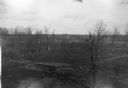
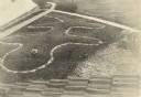
| Date: | 06 27 1927 |
|---|---|
| Description: | Aerial view of the effigy mound on Henry Wehmhoff's Riverview Farm. State Trunk Highway 83 runs through the effigy. |
| Date: | 05 04 1915 |
|---|---|
| Description: | Elevated view of a double water spirit effigy mound 4 miles south of Stockbridge near Appleton. The spirit has no head but the necks unite. |

| Date: | 04 12 1912 |
|---|---|
| Description: | Diagram of a bird effigy mound found in Frost's Woods, Blooming Grove Township. |
| Date: | 1919 |
|---|---|
| Description: | Elevated view of a four-footed American Indian effigy mound on the grounds of the Mendota State Hospital (Mendota Mental Health Institute). |
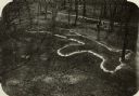
| Date: | |
|---|---|
| Description: | Elevated view of bear effigy mound outlined in chalk at Lake Koshkonong. |
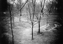
| Date: | |
|---|---|
| Description: | A turtle effigy mound on the University of Wisconsin-Madison campus, outlined by melting snow. |
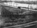
| Date: | 1905 |
|---|---|
| Description: | View of an Indian intaglio effigy, the only one still in existence in Wisconsin. The effigy is in the shape of a panther. There is a car on the road in the... |
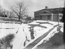
| Date: | |
|---|---|
| Description: | A view of a two-tailed water spirit burial mound on the grounds of the University of Wisconsin-Madison campus near Observatory Hill. |
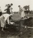
| Date: | 05 30 1931 |
|---|---|
| Description: | W.P. and Vivian Morgan, Grace Rollins and ? Mills excavate a burial mound in the Outlet group at the foot of Lake Monona. |
If you didn't find the material you searched for, our Library Reference Staff can help.
Call our reference desk at 608-264-6535 or email us at: