 Search: mounds
Filter: Categories of Wisconsin Historical Images
Filter: Subject of mounds
Filter: Year of 1800-1899
Filter: Year of 1890-1899
Search: mounds
Filter: Categories of Wisconsin Historical Images
Filter: Subject of mounds
Filter: Year of 1800-1899
Filter: Year of 1890-1899
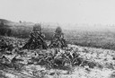
| Date: | 1890 |
|---|---|
| Description: | At the Aztalan Indian Mounds a group of people are standing on a hillside in the background. In the foreground are corn shocks. |

| Date: | 1892 |
|---|---|
| Description: | This map oriented with north to the upper left shows railroads, creeks, post offices, smaller lakes, Lake Mendota, Lake Monona, Lake Wingra, Lake Waubesa, ... |

| Date: | 1892 |
|---|---|
| Description: | Topographical map of Madison and surrounding communities which include Lake Mendota, Lake Monona, Lake Waubesa and Lake Kegonsa. The red dots on the map sh... |

| Date: | 06 25 1899 |
|---|---|
| Description: | A group of children and adults excavating an oval mound in the Teller Group. |
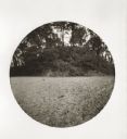
| Date: | 05 11 1894 |
|---|---|
| Description: | East side view of an Indian Mound (Big Grave). |
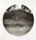
| Date: | 05 11 1894 |
|---|---|
| Description: | South side view of an Indian Mound with a fence in front of it. |
If you didn't find the material you searched for, our Library Reference Staff can help.
Call our reference desk at 608-264-6535 or email us at:
