 Search: mounds
Filter: Categories of Wisconsin Historical Images
Filter: Subject of mounds
Search: mounds
Filter: Categories of Wisconsin Historical Images
Filter: Subject of mounds
| Date: | |
|---|---|
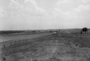
| Description: | View of Aztalan State Park site when it was called Aztalan Mound Park. |

| Date: | 1851 |
|---|---|
| Description: | Diagram of an effigy mound in the shape of a cross. |

| Date: | 1924 |
|---|---|
| Description: | This pictorial map focuses on the Madison Isthmus, Lake Mendota, Lake Monona, Lake Wingra, and shows points of historical interest, buildings, parks, and I... |

| Date: | 1933 |
|---|---|
| Description: | Blue print and blue line print maps that show local streets, Nakoma Country Club, part of Lake Forest, and part of Lake Wingra. A legend is included that s... |

| Date: | 1864 |
|---|---|
| Description: | This map is pen and watercolor on paper and shows a profile and geological sections of the Spensley Break, James Break, Wisconsin River, and Little Bear Cr... |

| Date: | 1873 |
|---|---|
| Description: | A map of the township of Primrose from the "Atlas of Dane County." |
| Date: | 1963 |
|---|---|
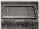
| Description: | The marker notes Man Mound Park by the Wisconsin Archeological Society, Sauk County Historical Society and the Landmark Committee, W.F.W.C. |

| Date: | |
|---|---|
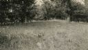
| Description: | A large burial mound near the south side of Governor Nelson State Park. |

| Date: | 1864 |
|---|---|
| Description: | This map is pen and watercolor on paper and shows a profile and geological sections of the East Blue Mound Break, Blue Mound Creek, Black Earth River, and ... |

| Date: | 06 30 1939 |
|---|---|
| Description: | A drawing of a lizard-shaped Indian mound at Hudson Park. |
| Date: | 1914 |
|---|---|
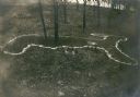
| Description: | Deer or rabbit effigy mound outlined with lime (ca. 800-1100 A.D.), at the McConnell mound group. |
| Date: | |
|---|---|
| Description: | An animal effigy burial mound at the Williams South mound group on the north shore of Lake Kegonsa. |

| Date: | 1828 |
|---|---|
| Description: | Plat of the Private Claims at Prairie Du Chien. |
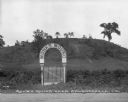
| Date: | |
|---|---|
| Description: | View of a gate and sign at Monks Mound, an archaeological site. Caption reads: "Monks Mound near Edwardsville, Ill." |

| Date: | 1930 |
|---|---|
| Description: | Poppies are blooming in a large field with a hill in the background. The photographer identifies the hill as a shell mound. The shell mound is likely the l... |

| Date: | 01 1969 |
|---|---|
| Description: | A map of Oneida county, which includes a small drawing of a hodag. |

| Date: | |
|---|---|
| Description: | Tapes and pins mark the locations of Native American corn hills in what is now Governor Nelson State Park. |

| Date: | 2009 |
|---|---|
| Description: | Watercolor of a Native American burial site. Generalized cross-section and stratigraphy of a typical Late Woodland effigy mound in Wisconsin. |

| Date: | 06 27 1927 |
|---|---|
| Description: | Aerial view of the effigy mound on Henry Wehmhoff's Riverview Farm. State Trunk Highway 83 runs through the effigy. |

| Date: | 1872 |
|---|---|
| Description: | This map, which includes eastern Iowa, northern Illinois and a portion of Michigan's Upper peninsula, shows the township survey grid and identifies countie... |
If you didn't find the material you searched for, our Library Reference Staff can help.
Call our reference desk at 608-264-6535 or email us at: