 Search: mounds
Filter: Categories of Wisconsin Historical Images
Filter: Subject of mounds
Search: mounds
Filter: Categories of Wisconsin Historical Images
Filter: Subject of mounds

| Date: | 01 12 2016 |
|---|---|
| Description: | View looking down at the Save the Mounds demonstration on the ground floor of the Wisconsin State Capitol against Assembly Bill 620. In the center is a dru... |

| Date: | 01 12 2016 |
|---|---|
| Description: | A demonstrator sits with his dog during the Save the Mounds demonstration around the Capitol Square against Assembly Bill 620. He is holding a sign explain... |

| Date: | 01 12 2016 |
|---|---|
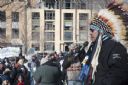
| Description: | Save the Mounds demonstration around the Capitol Square against Assembly Bill 620. Chief Clayton Winneshiek of the Ho Chunk Nation, wearing a headdress, is... |

| Date: | 01 12 2016 |
|---|---|
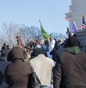
| Description: | Save the Mounds demonstration around the Capitol Square against Assembly Bill 620. In the center, Brandon Stevens, of the Oneida Tribe, speaks to the crowd... |

| Date: | 01 12 2016 |
|---|---|
| Description: | Save the Mounds demonstration around the Capitol Square against Assembly Bill 620. A Native American man dressed in traditional clothing walks up the steps... |

| Date: | 1800 |
|---|---|
| Description: | An ink on paper map for a plan of mounds in Milwaukee county. The map is situated pointing north. |
| Date: | 01 12 2016 |
|---|---|
| Description: | Save the Mounds demonstration around the Capitol Square against Assembly Bill 620. Chief Clayton Winneshiek of the Ho Chunk Nation, wearing a headdress, is... |

| Date: | 1850 |
|---|---|
| Description: | Diagrams of four effigy mounds surveyed by Increase A. Lapham and W.H. Canfield in 1850. No. 1 is an unidentified animal shape, No. 2 consists of two linea... |

| Date: | |
|---|---|
| Description: | Three separate maps: Ancient Works Near Manitowoc (surveyed 1850), Ancient Works on the North Side of Lake Wingra (surveyed 1850), and Mounds at Madison (s... |
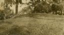
| Date: | |
|---|---|
| Description: | A linear burial mound at the T. Lewis Mound group in what is now Indian Mounds Park. |

| Date: | 01 01 1852 |
|---|---|
| Description: | These manuscript maps, drawn by William H. Canfield in 1852, illustrate mounds primarily in Sauk County, Wisconsin, in the towns of Greenfield, La Valle, M... |

| Date: | 01 12 2016 |
|---|---|
| Description: | Save the Mounds demonstration at the Capitol Square against Assembly Bill 620. Flag and Standard bearers are lined up behind the speakers. In the backgroun... |

| Date: | 01 12 2016 |
|---|---|
| Description: | Save the Mounds demonstration around the Capitol Square against Assembly Bill 620. In the foreground, seen from behind, is the headdress worn by Chief Clay... |
| Date: | 01 12 2016 |
|---|---|
| Description: | Save the Mounds demonstration at the Capitol Square against Assembly Bill 620. Wisconsin State Representative Robb Kahl is standing in the center speaking ... |
| Date: | 1890 |
|---|---|
| Description: | At the Aztalan Indian Mounds a group of people are standing on a hillside in the background. In the foreground are corn shocks. |
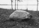
| Date: | |
|---|---|
| Description: | View of a rock with a plaque that reads: "Group of Prehistoric Indian Burial Mounds and Winnebago Village Site. Marked by the Delavan Woman's Club - May 19... |
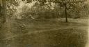
| Date: | |
|---|---|
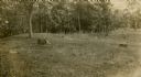
| Description: | Oval burial mound at the T. Lewis Mound group in what is now Indian Mounds Park. |
| Date: | |
|---|---|
| Description: | A linear burial mound at the T. Lewis Mound group in what is now Indian Mounds Park. |

| Date: | 11 03 1903 |
|---|---|
| Description: | A drawing of a group of burial mounds in Linden Valley. Text on back reads: "These mounds lie at the narrow mouth of Linden Valley on the east side of the ... |
If you didn't find the material you searched for, our Library Reference Staff can help.
Call our reference desk at 608-264-6535 or email us at:
