 Search: mounds
Filter: Categories of Wisconsin Historical Images
Filter: Subject of state parks and reserves
Search: mounds
Filter: Categories of Wisconsin Historical Images
Filter: Subject of state parks and reserves

| Date: | |
|---|---|
| Description: | Photographic postcard of the view to the west from the top of Blue Mounds, in Blue Mounds State Park. Handwritten is "Platteville Mounds, 45 miles" with an... |

| Date: | |
|---|---|
| Description: | Photographic postcard of the northwest view of Blue Mounds. Text below in a white box reads "N.W. View of Blue Mounds, Wis. Elevation 1760 ft." |

| Date: | |
|---|---|
| Description: | Photographic postcard of an old Indian trail marker, a twisted tree, as seen on top of Blue Mounds. Text below reads: "'Old Indian Trail Marker' Top of Blu... |

| Date: | |
|---|---|
| Description: | Photographic postcard of the view towards Madison from the top of Blue Mounds. Handwritten on the card is "State Capitol, 25 miles" with an arrow. Text bel... |
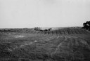
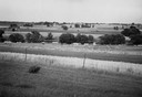
| Date: | 1945 |
|---|---|
| Description: | Field with contours, and two mounds. |
| Date: | |
|---|---|
| Description: | Photographic postcard of picnic grounds at a spring in Blue Mounds State Park. The spring is running out of a brick catch basin on the right. A woman weari... |
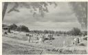
| Date: | |
|---|---|
| Description: | Photographic postcard view of the swimming pool on top of the mounds in Blue Mounds State Park. There are people swimming as well as standing around the si... |

| Date: | |
|---|---|
| Description: | Photographic postcard view of one of the Indian mounds at Aztalan State Park. Steps lead up to the top of the mound from the right, and a tall fence is beh... |

| Date: | 1920 |
|---|---|
| Description: | A map of the Nelson-Dewey State Park at the confluence of the Mississippi and Wisconsin rivers, showing the topographical features of the area, as well as ... |

| Date: | 06 01 1983 |
|---|---|
| Description: | Two people are leaning against a railing overlooking at forest. Caption reads: "Rachel Imsland, 25, and Mark Evans, 28, both of Iowa City, Iowa, viewed the... |

| Date: | 1920 |
|---|---|
| Description: | This 1920 map actually depicts present-day Wyalusing State Park at the confluence of the Mississippi and Wisconsin rivers in the Town of Wyalusing, Grant C... |
| Date: | |
|---|---|
| Description: | View of Aztalan State Park site when it was called Aztalan Mound Park. |

| Date: | 09 07 2014 |
|---|---|
| Description: | View from the top of a hill looking out to a valley, with clouds in the blue sky. Trees are framing the view, and in the foreground, a woman, the photograp... |
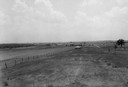
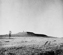
| Date: | 1945 |
|---|---|
| Description: | Field prior to the park's reconstruction, with a fence in the foreground. A river is at the bottom of the hill. |
| Date: | |
|---|---|
| Description: | View of the southwest pyramidal mound in Aztalan State Park as it appeared after restoration. A person is standing on top of the mound. |

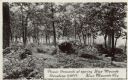
| Date: | |
|---|---|
| Description: | Photographic postcard view of three views from Aztalan State Park; Indian Mound at sunset, pottery, and a fence. |

| Date: | 03 31 1965 |
|---|---|
| Description: | Nature view with marshland sedges and rushes in foreground, Lake Kegonsa, and a tree-lined horizon. The newly acquired area consists of marsh, woodland, In... |
If you didn't find the material you searched for, our Library Reference Staff can help.
Call our reference desk at 608-264-6535 or email us at: