 Search: mounds
Filter: Categories of Wisconsin Historical Images
Filter: Subject of streets
Search: mounds
Filter: Categories of Wisconsin Historical Images
Filter: Subject of streets
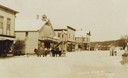
| Date: | 1910 |
|---|---|
| Description: | View of a main street during the winter. One horse is covered with a horse blanket. Caption reads: "Winter Scene at Blue Mounds Wis." |

| Date: | 01 12 2016 |
|---|---|
| Description: | Save the Mounds demonstration around the Capitol Square against Assembly Bill 620. Elevated view of the protesters on the Capitol grounds looking towards S... |

| Date: | 01 12 2016 |
|---|---|
| Description: | A demonstrator sits with his dog during the Save the Mounds demonstration around the Capitol Square against Assembly Bill 620. He is holding a sign explain... |

| Date: | 02 2014 |
|---|---|
| Description: | View across street towards the historic Blue Mounds Opera House. Exterior stairs lead to porches on the ground and second floor. A small metal fence surrou... |

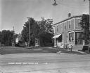
| Date: | 04 25 2012 |
|---|---|
| Description: | A view of a main street in the business district. |

| Date: | |
|---|---|
| Description: | Map showing Indian mounds in Milwaukee's Second Ward from a sketch made by Increase Lapham in 1836. Streets shown on the map include 6th Street, 5th Street... |

| Date: | |
|---|---|
| Description: | A vintage view and a modern view of buildings in the downtown area, presented as a pair. There is snow on the ground. The vintage view shows horses and wag... |

| Date: | 1840 |
|---|---|
| Description: | This map shows local streets, numbered lots, and part of Blue Mounds Branch. The map reads: "NE 1/4 NW 1/4 Sect. 16 - T5 - R5E." under the title and is dat... |
| Date: | 1930 |
|---|---|
| Description: | A man and his two children pose at the corner near the post office. |

| Date: | 1892 |
|---|---|
| Description: | Topographical map of Madison and surrounding communities which include Lake Mendota, Lake Monona, Lake Waubesa and Lake Kegonsa. The red dots on the map sh... |

| Date: | 1924 |
|---|---|
| Description: | A map of the Madison Township, T7N R9E including Lake Mendota showing the location of Ho Chunk encampments and effigy mounds. |
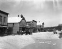
| Date: | |
|---|---|
| Description: | A snow-covered street with several horses standing at the curb. Groups of people pose on the porches of the hotel and the post office. |

| Date: | 1933 |
|---|---|
| Description: | Blue print and blue line print maps that show local streets, Nakoma Country Club, part of Lake Forest, and part of Lake Wingra. A legend is included that s... |

| Date: | |
|---|---|
| Description: | A view of a retail street from the intersection. From the corner of the street, there is a restaurant, hotel, and post office. On the sidewalk, men sit on ... |

| Date: | 1945 |
|---|---|
| Description: | This maps shows roads, railroads, parks, recreational areas, Lake Wingra, Lake Monona, and part of Lake Mendota. The map includes pictorial images that dep... |
If you didn't find the material you searched for, our Library Reference Staff can help.
Call our reference desk at 608-264-6535 or email us at:
