 Search: mounds
Filter: Categories of Wisconsin Historical Images
Filter: Subject of water
Search: mounds
Filter: Categories of Wisconsin Historical Images
Filter: Subject of water

| Date: | 1957 |
|---|---|
| Description: | Color postcard of Dream River, North Cave, opened in 1957, in the Cave of the Mounds. |
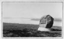
| Date: | 1930 |
|---|---|
| Description: | View of an Indian mounds marker on the St. Croix River. |

| Date: | 1941 |
|---|---|
| Description: | The typed caption on the reverse of this photograph explains: "On the bridge above the underground lake in Cave of the Mounds at Blue Mounds, Wis., Arthur ... |

| Date: | 1916 |
|---|---|
| Description: | In 1916, it was estimated that 15,000 Indian mounds had formerly existed in Wisconsin. In the early 20th century, the Wisconsin Archaeological Society surv... |

| Date: | |
|---|---|
| Description: | Ink and watercolor of prehistoric mounds near the mouth of Haigs Creek and the Scioto River. |

| Date: | 1920 |
|---|---|
| Description: | Two cottages at Burgy Mounds on Lake Koshkonong. |
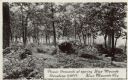
| Date: | |
|---|---|
| Description: | Photographic postcard of picnic grounds at a spring in Blue Mounds State Park. The spring is running out of a brick catch basin on the right. A woman weari... |
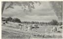
| Date: | |
|---|---|
| Description: | Photographic postcard view of the swimming pool on top of the mounds in Blue Mounds State Park. There are people swimming as well as standing around the si... |

| Date: | 1947 |
|---|---|
| Description: | Colorized postcard of a girl throwing a penny into the Brownie's Wishing Well in the Cave of the Mounds. Caption reads: "Brownie's Wishing Well." |

| Date: | |
|---|---|
| Description: | Three separate maps: Ancient Works Near Manitowoc (surveyed 1850), Ancient Works on the North Side of Lake Wingra (surveyed 1850), and Mounds at Madison (s... |
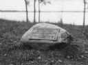
| Date: | |
|---|---|
| Description: | View of a rock with a plaque that reads: "Group of Prehistoric Indian Burial Mounds and Winnebago Village Site. Marked by the Delavan Woman's Club - May 19... |

| Date: | 1867 |
|---|---|
| Description: | This 1867 manuscript map by Increase Lapham shows the topography and geology of the Blue Mounds region in the Town of Brigham in Iowa County and the towns ... |

| Date: | |
|---|---|
| Description: | A hand-colored geological cross section of Iowa County and eastern Dane County, Wisconsin, from the Blue Mounds north-northwest to the sandy plain of the W... |

| Date: | 1850 |
|---|---|
| Description: | This 1850 survey by William H. Canfield shows the mounds near Wiegands Bay on the Wisconsin River in the Town of Merrimac, Sauk County, Wisconsin. |

| Date: | 1851 |
|---|---|
| Description: | Map of a portion of Merton including the Bark River, a mill, Fort Hill, and Indian mounds. |

| Date: | |
|---|---|
| Description: | View of burial mounds in a park on the edge of a lake. Caption reads: "Indian Burial Grounds in Wakanda Park, Menomonie, Wis." |

| Date: | 1866 |
|---|---|
| Description: | A map of Lafayette County, Wisconsin, showing the townships and ranges, sections, towns, villages, stream and rivers, mounds, mineral deposits and the Mine... |

| Date: | 1941 |
|---|---|
| Description: | This pictorial map shows sites related to Indian legends, mounds, and trails in the Chain O' Lakes region in southwestern Waupaca County, Wisconsin. |

| Date: | 1903 |
|---|---|
| Description: | This maps shows what may be Ho Chunk Native American burial mounds. Also noted on the map is the Fox River, the Doty homestead, stockade embankment, the We... |

| Date: | 1864 |
|---|---|
| Description: | This map is pen and watercolor on paper and shows a profile and geological sections of the Blue Mounds, Hollow Run, Bogies Hollow Run, Bear Creek, East Bre... |
If you didn't find the material you searched for, our Library Reference Staff can help.
Call our reference desk at 608-264-6535 or email us at: