 Search: mounds
Filter: Categories of Wisconsin Historical Images
Filter: Subject of wisconsin
Search: mounds
Filter: Categories of Wisconsin Historical Images
Filter: Subject of wisconsin

| Date: | 1916 |
|---|---|
| Description: | In 1916, it was estimated that 15,000 Indian mounds had formerly existed in Wisconsin. In the early 20th century, the Wisconsin Archaeological Society surv... |
| Date: | 08 1905 |
|---|---|
| Description: | A visitor takes in the sight of three linear burial mounds at the Sure-Johnson mound group south of McFarland, Wisconsin. |

| Date: | 1850 |
|---|---|
| Description: | Diagrams of four effigy mounds surveyed by Increase A. Lapham and W.H. Canfield in 1850. No. 1 is an unidentified animal shape, No. 2 consists of two linea... |
| Date: | |
|---|---|
| Description: | A linear burial mound at the T. Lewis Mound group in what is now Indian Mounds Park. |
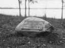
| Date: | |
|---|---|
| Description: | View of a rock with a plaque that reads: "Group of Prehistoric Indian Burial Mounds and Winnebago Village Site. Marked by the Delavan Woman's Club - May 19... |
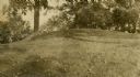
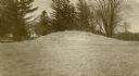
| Date: | |
|---|---|
| Description: | Oval burial mound at the T. Lewis Mound group in what is now Indian Mounds Park. |
| Date: | |
|---|---|
| Description: | A linear burial mound at the T. Lewis Mound group in what is now Indian Mounds Park. |
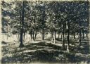
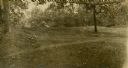
| Date: | |
|---|---|
| Description: | Two men enjoy the shade among Native American burial mounds on the Dividing Ridge, a recessional moraine, between Lakes Monona and Wingra in Madison, Wisco... |

| Date: | 1851 |
|---|---|
| Description: | Map of a portion of Merton including the Bark River, a mill, Fort Hill, and Indian mounds. |
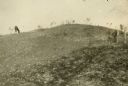
| Date: | 1913 |
|---|---|
| Description: | One of the large burial mounds of the Outlet mound group on the former Hoyt property at the foot of Lake Monona. |
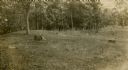
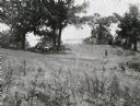
| Date: | 1909 |
|---|---|
| Description: | A horse grazes near Native American burial mounds on the Dividing Ridge, a recessional moraine, between Lakes Monona and Wingra in Madison, Wisconsin. The ... |

| Date: | 1915 |
|---|---|
| Description: | A row of conical burial mounds adjoins the Park and Pleasure Drive on the north shore of Lake Wingra (now Edgewood Drive, at the south edge of Edgewood Col... |

| Date: | 1941 |
|---|---|
| Description: | This pictorial map shows sites related to Indian legends, mounds, and trails in the Chain O' Lakes region in southwestern Waupaca County, Wisconsin. |

| Date: | 10 1911 |
|---|---|
| Description: | This map shows lot numbers, building lines, roads, trees, and Indian mounds. Relief is shown by contours. Includes manuscript annotations marking parks. |

| Date: | |
|---|---|
| Description: | Wisconsin Memorial Hospital with a key to buildings in the upper left. Indian mounds are marked on the site. Arthur Peabody was the state architect for th... |

| Date: | |
|---|---|
| Description: | Map showing Indian mounds in Milwaukee's Second Ward from a sketch made by Increase Lapham in 1836. Streets shown on the map include 6th Street, 5th Street... |

| Date: | 10 07 1914 |
|---|---|
| Description: | Sara (Mrs. Joseph) Mallon (Menominee) of Milwaukee, wearing a sash stands between two American flags behind a memorial that reads, "Indian Mounds: One of s... |

| Date: | 1850 |
|---|---|
| Description: | Map showing Indian mounds and graves as well as ground cover types at Township 8, Range 22. There is an inset diagram of an effigy mound labeled "The Cross... |

| Date: | 1925 |
|---|---|
| Description: | This map shows trails, mounds, villages, corn fields, and contemporary civil townships; some villages and features include both Indian and English place na... |

| Date: | 1927 |
|---|---|
| Description: | Blueprint-style map of Frost Woods on the shore of Lake Monona. The map indicates the locations of Indian mounds, an Indian camp, and various plants. There... |
If you didn't find the material you searched for, our Library Reference Staff can help.
Call our reference desk at 608-264-6535 or email us at: