 Search: mounds
Filter: Categories of Wisconsin Historical Images
Filter: Year of 1800-1899
Search: mounds
Filter: Categories of Wisconsin Historical Images
Filter: Year of 1800-1899
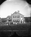
| Date: | 1879 |
|---|---|
| Description: | Harold and Gunhild Mickelson with five of their daughters (Bertha Mickelson Bragger and her husband are standing on the right), in Section 23 of the Town o... |

| Date: | 1869 |
|---|---|
| Description: | Mixed group, mostly children, having a picnic in the woods, perhaps connected with the dedication of the East Blue Mounds Lutheran Church. |

| Date: | 1859 |
|---|---|
| Description: | Shows townships and sections, landownership, roads, railroads, rural residences, schools, churches, and topography. Relief shown by hachures. "From governm... |
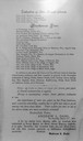
| Date: | 1876 |
|---|---|
| Description: | The fourth an last page of Dahl's 1877 "Catalogue of Stereoscopic Views made and published by Andrew L. Dahl, landscape photographer, DeForest, Wis." which... |

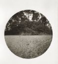
| Date: | 06 25 1899 |
|---|---|
| Description: | A group of children and adults excavating an oval mound in the Teller Group. |

| Date: | 1864 |
|---|---|
| Description: | This map is pen and watercolor on paper and shows a profile and geological sections of the Apple River, Little Otter Creek, Woods' Branch, Bonners' Branch,... |

| Date: | 1859 |
|---|---|
| Description: | Map featuring various views of buildings and scenes from Sauk County. |

| Date: | 1864 |
|---|---|
| Description: | This map is pen and watercolor on paper and shows a profile and geological sections of the Spensley Break, James Break, Wisconsin River, and Little Bear Cr... |

| Date: | 1851 |
|---|---|
| Description: | Diagram of an effigy mound in the shape of a cross. |

| Date: | 1873 |
|---|---|
| Description: | A map of the township of Primrose from the "Atlas of Dane County." |

| Date: | 1844 |
|---|---|
| Description: | A hand-colored map and chart showing a geological cross-section from Rockingham, in present-day Scott County, Iowa, through Blue Mounds to the Wisconsin Ri... |

| Date: | 1864 |
|---|---|
| Description: | This map is pen and watercolor on paper and shows a profile and geological sections of the East Blue Mound Break, Blue Mound Creek, Black Earth River, and ... |

| Date: | 1828 |
|---|---|
| Description: | Plat of the Private Claims at Prairie Du Chien. |

| Date: | 1872 |
|---|---|
| Description: | This map, which includes eastern Iowa, northern Illinois and a portion of Michigan's Upper peninsula, shows the township survey grid and identifies countie... |

| Date: | 1864 |
|---|---|
| Description: | This map shows locations of quarries, sink holes, creeks, springs, rivers, houses, forts, and roads. Annotations in pencil read: "Is the top of the mound l... |
| Date: | 05 11 1894 |
|---|---|
| Description: | East side view of an Indian Mound (Big Grave). |
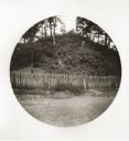
| Date: | 05 11 1894 |
|---|---|
| Description: | South side view of an Indian Mound with a fence in front of it. |

| Date: | 1896 |
|---|---|
| Description: | This map shows railroads, ordinary roads, good roads, township lines, county lines, county boundaries, towns, lakes, and rivers in the southeastern part ... |
If you didn't find the material you searched for, our Library Reference Staff can help.
Call our reference desk at 608-264-6535 or email us at:

