 Search: mounds
Filter: Categories of Wisconsin Historical Images
Filter: Year of 1800-1899
Search: mounds
Filter: Categories of Wisconsin Historical Images
Filter: Year of 1800-1899

| Date: | 1864 |
|---|---|
| Description: | This map is pen and watercolor on paper and shows a profile and the geological formation of Blue Mound. Also shown is the location of Arnold's Hotel and Br... |

| Date: | 1864 |
|---|---|
| Description: | This map shows locations of quarries, sink holes, creeks, springs, rivers, houses, forts, and roads. |

| Date: | 05 1833 |
|---|---|
| Description: | Painting of Black Hawk by Robert M. Sully. Black Hawk, a Native American Sauk warrior and leader, sought to attack and drive out the settlers in the Blue M... |

| Date: | 1839 |
|---|---|
| Description: | A chart showing the geological cross-section and the height above the surrounding landscape of several locations, such as Platte Mound in Wisconsin, and th... |

| Date: | 1864 |
|---|---|
| Description: | This map shows locations of quarries, sink holes, creeks, springs, rivers, houses, forts, and roads. The upper right corner and right margin includes anno... |

| Date: | 1845 |
|---|---|
| Description: | Map of Wisconsin, including lower western border with Iowa, southern border along Illinois, eastern shoreline of Lake Michigan, and northern area along Wis... |

| Date: | 1864 |
|---|---|
| Description: | Map showing locations of quarries, sink holes, creeks, springs, rivers, houses, forts, and roads. The map appears to have been drawn on to of a plat map of... |
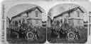
| Date: | 08 29 1876 |
|---|---|
| Description: | The extended family of Aslak Olsen Lie posing before the home he built in 1849 with his brother Ole after immigrating in 1848. The house is a combination o... |
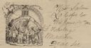
| Date: | 06 14 1862 |
|---|---|
| Description: | Letterhead featuring a scene of men and women raising their hands in the air. The two men in front are holding a sickle and the American flag, other people... |
If you didn't find the material you searched for, our Library Reference Staff can help.
Call our reference desk at 608-264-6535 or email us at: