Search: mounds
Filter: Creator Name of Unknown
Search: mounds
Filter: Creator Name of Unknown

| Date: | 07 22 1995 |
|---|---|
| Description: | Brian Bigler (right) and Ken Scott (left) on July 22, 1995 at the reception for their Holy Union Ceremony, which was held at Brigham Park, Blue Mounds, Wis... |
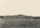
| Date: | 1920 |
|---|---|
| Description: | Elevated view of a mining community, including numerous houses, mining structures, and large mounds of gravel material. |

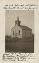
| Date: | 1925 |
|---|---|
| Description: | Adams house and store. John Adams sold pork, flour, and other merchandise during mining days. Said to be the birthplace of Aliva Adams, afterwards the Gove... |

| Date: | 04 21 1911 |
|---|---|
| Description: | Group of men and a young boy breaking hemp at the Brigham farm. |

| Date: | 1840 |
|---|---|
| Description: | This map shows local streets, numbered lots, and part of Blue Mounds Branch. The map reads: "NE 1/4 NW 1/4 Sect. 16 - T5 - R5E." under the title and is dat... |

| Date: | 1892 |
|---|---|
| Description: | Topographical map of Madison and surrounding communities which include Lake Mendota, Lake Monona, Lake Waubesa and Lake Kegonsa. The red dots on the map sh... |

| Date: | 1927 |
|---|---|
| Description: | Blueprint-style map of Frost Woods on the shore of Lake Monona. The map indicates the locations of Indian mounds, an Indian camp, and various plants. There... |
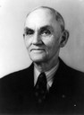
| Date: | |
|---|---|
| Description: | Quarter-length portrait of Charles E. Brown. Brown as an archeologist primarily responsible for saving more than one hundred Indian mounds from destruction... |

| Date: | |
|---|---|
| Description: | This map is pen-and-ink on tracing paper with a mounted legend and shows the Kickapoo River, Indian mounds, the 1st Fort Crawford, an Indian Agency, the si... |
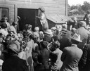
| Date: | 1915 |
|---|---|
| Description: | Belle Case La Follette, wife of Robert M. La Follette, Sr., addressing a group of farmers during a tour on the Chautauqua circuit during which she frequent... |

| Date: | 1915 |
|---|---|
| Description: | This 1915 map covers portions of Barron, Chippewa, and Rusk counties in Wisconsin. Shown are the township and range grid, sections, cities and villages, ra... |

| Date: | 1859 |
|---|---|
| Description: | Map featuring various views of buildings and scenes from Sauk County. |

| Date: | 1873 |
|---|---|
| Description: | A map of the township of Primrose from the "Atlas of Dane County." |

| Date: | 1948 |
|---|---|
| Description: | The John H. Rountree House, built in 1854. According to "The History of Wisconsin" (Vol. I, 1973), "The rise of the settlement at Platte Mounds was indisso... |
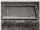
| Date: | 1963 |
|---|---|
| Description: | The marker notes Man Mound Park by the Wisconsin Archeological Society, Sauk County Historical Society and the Landmark Committee, W.F.W.C. |

| Date: | |
|---|---|
| Description: | A large burial mound near the south side of Governor Nelson State Park. |
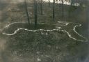
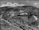
| Date: | 1914 |
|---|---|
| Description: | Deer or rabbit effigy mound outlined with lime (ca. 800-1100 A.D.), at the McConnell mound group. |
If you didn't find the material you searched for, our Library Reference Staff can help.
Call our reference desk at 608-264-6535 or email us at: