Search: mounds
Filter: Creator Name of Unknown
Filter: Year of 1900-1999
Search: mounds
Filter: Creator Name of Unknown
Filter: Year of 1900-1999
| Date: | 1910 |
|---|---|
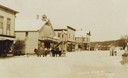
| Description: | View of a main street during the winter. One horse is covered with a horse blanket. Caption reads: "Winter Scene at Blue Mounds Wis." |
| Date: | 1930 |
|---|---|
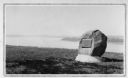
| Description: | View of an Indian mounds marker on the St. Croix River. |
| Date: | 1910 |
|---|---|
| Description: | Distant view of the town, with railroad tracks in foreground. The church is the highest point in the image. "General View. Blue Mounds in the Distance. Alt... |

| Date: | 1925 |
|---|---|
| Description: | A view of Tenpin Alley (rear) active in lead mining days. |

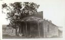
| Date: | 1925 |
|---|---|
| Description: | This building was said to have been an early residence. |

| Date: | 1969 |
|---|---|
| Description: | A girl is standing high up among a group of stalagmites in the Cave of the Mounds. Another girl is leaning against a railing on the left. |
| Date: | 1925 |
|---|---|
| Description: | A view of the front of Tenpin Alley, active in lead mining days. |
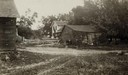
| Date: | 06 1925 |
|---|---|
| Description: | View of three farm buildings - the one in the center is collapsing. |

| Date: | 05 05 1939 |
|---|---|
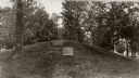
| Description: | Charles E. Brown poses near a historic tablet marking one of a row of conical burial mounds on the Park and Pleasure drive on the north shore of Lake Wingr... |

| Date: | 1910 |
|---|---|
| Description: | A sightseeing party wanders among cows and Native American burial mounds near the popular picnic area at Merrill Springs, on the south shore of Lake Mendot... |
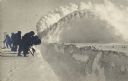
| Date: | 1916 |
|---|---|
| Description: | Winter scene with men clearing a pathway through mounds of snow, New Richmond, Wisconsin. |

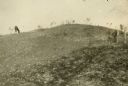
| Date: | 1923 |
|---|---|
| Description: | A man in the distance stands on a mound, which is part of a group of mounds near the Fox River. Many artifacts including arrowheads and human bones have be... |
| Date: | 1909 |
|---|---|
| Description: | A horse grazes near Native American burial mounds on the Dividing Ridge, a recessional moraine, between Lakes Monona and Wingra in Madison, Wisconsin. The ... |

| Date: | 1903 |
|---|---|
| Description: | This maps shows what may be Ho Chunk Native American burial mounds. Also noted on the map is the Fox River, the Doty homestead, stockade embankment, the We... |

| Date: | 1900 |
|---|---|
| Description: | This photocopy map shows marshes, woods, buildings, and selected features including islands, mounds, old Fort Crawford, and "new site for a fort in questio... |
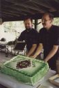
| Date: | 07 22 1995 |
|---|---|
| Description: | Brian Bigler (right) and Ken Scott (left) on July 22, 1995 at the reception for their Holy Union Ceremony, which was held at Brigham Park, Blue Mounds, Wis... |
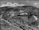
| Date: | 1920 |
|---|---|
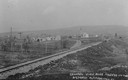
| Description: | Elevated view of a mining community, including numerous houses, mining structures, and large mounds of gravel material. |

| Date: | 1925 |
|---|---|
| Description: | Adams house and store. John Adams sold pork, flour, and other merchandise during mining days. Said to be the birthplace of Aliva Adams, afterwards the Gove... |

| Date: | 04 21 1911 |
|---|---|
| Description: | Group of men and a young boy breaking hemp at the Brigham farm. |
If you didn't find the material you searched for, our Library Reference Staff can help.
Call our reference desk at 608-264-6535 or email us at: