Search: mounds
Filter: Subject of human settlements
Search: mounds
Filter: Subject of human settlements

| Date: | 1828 |
|---|---|
| Description: | Plat of the Private Claims at Prairie Du Chien. |

| Date: | 01 1969 |
|---|---|
| Description: | A map of Oneida county, which includes a small drawing of a hodag. |

| Date: | |
|---|---|
| Description: | A view of a retail street from the intersection. From the corner of the street, there is a restaurant, hotel, and post office. On the sidewalk, men sit on ... |

| Date: | 1872 |
|---|---|
| Description: | This map, which includes eastern Iowa, northern Illinois and a portion of Michigan's Upper peninsula, shows the township survey grid and identifies countie... |

| Date: | 1864 |
|---|---|
| Description: | This map shows locations of quarries, sink holes, creeks, springs, rivers, houses, forts, and roads. Annotations in pencil read: "Is the top of the mound l... |
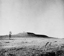
| Date: | 09 28 1942 |
|---|---|
| Description: | Elevated view of turtle mound on the University of Wisconsin-Madison campus. |

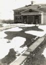
| Date: | 04 12 1912 |
|---|---|
| Description: | Diagram of a bird effigy mound found in Frost's Woods, Blooming Grove Township. |
| Date: | |
|---|---|
| Description: | View of the southwest pyramidal mound in Aztalan State Park as it appeared after restoration. A person is standing on top of the mound. |
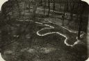
| Date: | |
|---|---|
| Description: | Elevated view of bear effigy mound outlined in chalk at Lake Koshkonong. |

| Date: | 1901 |
|---|---|
| Description: | Plat map showing land ownership of Township 21N Range 3W in Jackson County for 1901. Scale is 2 inches to 1 mile. |
| Date: | |
|---|---|
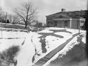
| Description: | A turtle effigy mound on the University of Wisconsin-Madison campus, outlined by melting snow. |
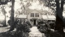
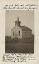
| Date: | 07 1933 |
|---|---|
| Description: | Front view of Man Mound House, with trees and a walkway which leads to the front door. The walkway appears to be on a mound. |
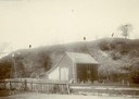
| Date: | |
|---|---|
| Description: | View of large platform mound with small barn in the foreground. The numbers 1, 2, and 3 are written on the photograph in ink. |
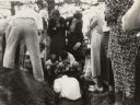
| Date: | 1935 |
|---|---|
| Description: | Members of the Wisconsin Outing Club watch the excavation of a burial mound at the Outlet group in 1935. |

| Date: | |
|---|---|
| Description: | An unusual burial mound in the Willow Drive mound group on the University of Wisconsin-Madison campus, prior to its excavation by Charles E. Brown. |

| Date: | 02 1910 |
|---|---|
| Description: | Farmer and two cows standing outside near a barn in winter. |

| Date: | 1896 |
|---|---|
| Description: | This map shows railroads, ordinary roads, good roads, township lines, county lines, county boundaries, towns, lakes, and rivers in the southeastern part ... |

| Date: | 1864 |
|---|---|
| Description: | This map shows locations of quarries, sink holes, creeks, springs, rivers, houses, forts, and roads. |

| Date: | 1944 |
|---|---|
| Description: | Portage County Map. Includes the towns of Eau Plaine, Dewey, Sharon, Alban, Carson, Hull, New Hope, Linwood, Stockton, Amherst, Plover, Grant, Buena Vista,... |
If you didn't find the material you searched for, our Library Reference Staff can help.
Call our reference desk at 608-264-6535 or email us at: