 Search: mounds
Filter: Subject of human settlements
Search: mounds
Filter: Subject of human settlements

| Date: | 01 12 2016 |
|---|---|
| Description: | Save the Mounds demonstration around the Capitol Square against Assembly Bill 620. In the center, Brandon Stevens, of the Oneida Tribe, speaks to the crowd... |

| Date: | 01 12 2016 |
|---|---|
| Description: | Save the Mounds demonstration around the Capitol Square against Assembly Bill 620. A Native American man dressed in traditional clothing walks up the steps... |
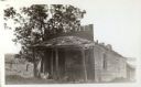
| Date: | 1925 |
|---|---|
| Description: | A view of the front of Tenpin Alley, active in lead mining days. |

| Date: | 01 12 2016 |
|---|---|
| Description: | Save the Mounds demonstration around the Capitol Square against Assembly Bill 620. Chief Clayton Winneshiek of the Ho Chunk Nation, wearing a headdress, is... |

| Date: | 01 12 2016 |
|---|---|
| Description: | Save the Mounds demonstration around the Capitol Square against Assembly Bill 620. An individual speaks with a crowd in front of him and flag and standards... |
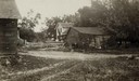
| Date: | 06 1925 |
|---|---|
| Description: | View of three farm buildings - the one in the center is collapsing. |
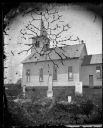
| Date: | 1876 |
|---|---|
| Description: | East Blue Mounds Lutheran Church, formerly Norsk Evangelisk Kirke, built in 1868. The graves of Andreas L. Dahl's mother, Berthe Nelsdatter (Lund) Dahlen, ... |

| Date: | 01 01 1852 |
|---|---|
| Description: | These manuscript maps, drawn by William H. Canfield in 1852, illustrate mounds primarily in Sauk County, Wisconsin, in the towns of Greenfield, La Valle, M... |

| Date: | 01 12 2016 |
|---|---|
| Description: | Save the Mounds demonstration at the Capitol Square against Assembly Bill 620. Flag and Standard bearers are lined up behind the speakers. In the backgroun... |

| Date: | 01 12 2016 |
|---|---|
| Description: | Save the Mounds demonstration around the Capitol Square against Assembly Bill 620. In the foreground, seen from behind, is the headdress worn by Chief Clay... |

| Date: | 01 12 2016 |
|---|---|
| Description: | Save the Mounds demonstration at the Capitol Square against Assembly Bill 620. Wisconsin State Representative Robb Kahl is standing in the center speaking ... |

| Date: | 01 12 2016 |
|---|---|
| Description: | Save the Mounds demonstration around the Capitol Square against Assembly Bill 620. View of the protesters on the Capitol grounds looking towards State Stre... |

| Date: | 01 12 2016 |
|---|---|
| Description: | Save the Mounds demonstration around the Capitol Square against Assembly Bill 620. A group of protestors gather around the doors to the Capitol. One man ho... |
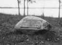
| Date: | |
|---|---|
| Description: | View of a rock with a plaque that reads: "Group of Prehistoric Indian Burial Mounds and Winnebago Village Site. Marked by the Delavan Woman's Club - May 19... |

| Date: | |
|---|---|
| Description: | A vintage view and a modern view of the same area in Blue Mounds, presented as a pair. The vintage view shows a road leading into the town. The modern view... |
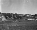
| Date: | 1930 |
|---|---|
| Description: | Bird's-eye view town. There are barns, homes, a church's steeple and a lumberyard. |

| Date: | 1915 |
|---|---|
| Description: | A row of conical burial mounds adjoins the Park and Pleasure Drive on the north shore of Lake Wingra (now Edgewood Drive, at the south edge of Edgewood Col... |

| Date: | 1866 |
|---|---|
| Description: | A map of Lafayette County, Wisconsin, showing the townships and ranges, sections, towns, villages, stream and rivers, mounds, mineral deposits and the Mine... |

| Date: | 02 2014 |
|---|---|
| Description: | View across street towards the historic Blue Mounds Opera House. Exterior stairs lead to porches on the ground and second floor. A small metal fence surrou... |

| Date: | 1903 |
|---|---|
| Description: | This maps shows what may be Ho Chunk Native American burial mounds. Also noted on the map is the Fox River, the Doty homestead, stockade embankment, the We... |
If you didn't find the material you searched for, our Library Reference Staff can help.
Call our reference desk at 608-264-6535 or email us at: