Search: mounds
Filter: Subject of human settlements
Filter: Year of 1900-1999
Search: mounds
Filter: Subject of human settlements
Filter: Year of 1900-1999
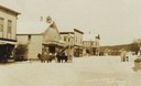
| Date: | 1910 |
|---|---|
| Description: | View of a main street during the winter. One horse is covered with a horse blanket. Caption reads: "Winter Scene at Blue Mounds Wis." |
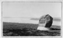
| Date: | 1930 |
|---|---|
| Description: | View of an Indian mounds marker on the St. Croix River. |
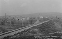
| Date: | 1910 |
|---|---|
| Description: | Distant view of the town, with railroad tracks in foreground. The church is the highest point in the image. "General View. Blue Mounds in the Distance. Alt... |

| Date: | 1948 |
|---|---|
| Description: | Colorized postcard of a Norwegian building at Little Norway in Blue Mounds. Built in Norway by the Norwegian Government, for the Columbian Exposition, Chic... |

| Date: | 1925 |
|---|---|
| Description: | A view of Tenpin Alley (rear) active in lead mining days. |

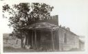
| Date: | 1925 |
|---|---|
| Description: | This building was said to have been an early residence. |
| Date: | 1925 |
|---|---|
| Description: | A view of the front of Tenpin Alley, active in lead mining days. |
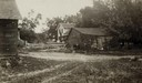
| Date: | 06 1925 |
|---|---|
| Description: | View of three farm buildings - the one in the center is collapsing. |
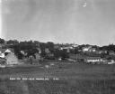
| Date: | 1930 |
|---|---|
| Description: | Bird's-eye view town. There are barns, homes, a church's steeple and a lumberyard. |

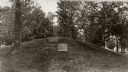
| Date: | 1915 |
|---|---|
| Description: | A row of conical burial mounds adjoins the Park and Pleasure Drive on the north shore of Lake Wingra (now Edgewood Drive, at the south edge of Edgewood Col... |

| Date: | 1903 |
|---|---|
| Description: | This maps shows what may be Ho Chunk Native American burial mounds. Also noted on the map is the Fox River, the Doty homestead, stockade embankment, the We... |

| Date: | 10 1911 |
|---|---|
| Description: | This map shows lot numbers, building lines, roads, trees, and Indian mounds. Relief is shown by contours. Includes manuscript annotations marking parks. |

| Date: | 1930 |
|---|---|
| Description: | Remains of the racetrack on the top of Blue Mound. |

| Date: | 1948 |
|---|---|
| Description: | Colorized postcard of a bedroom with a built-in bed with bed curtains, two chairs and a table. A large painting decorates the wall. Text below reads "Littl... |
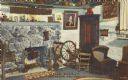
| Date: | 1948 |
|---|---|
| Description: | Colorized postcard of the main living area of a Norwegian dwelling at Little Norway showing a fireplace, cradle and spinning wheel. Pictures and household ... |
| Date: | 1930 |
|---|---|
| Description: | View of a wide path through trees in the spring or summer. |

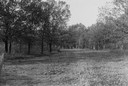
| Date: | 1930 |
|---|---|
| Description: | Aerial view of the town, including the central business district. |
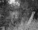
| Date: | 09 01 1963 |
|---|---|
| Description: | A view of an abandoned log cabin obscured by plants and trees. |
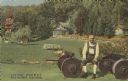
| Date: | 1948 |
|---|---|
| Description: | Colorized postcard of a scene at Little Norway. A man sits on a wagon chassis. He is wearing an ethnic costume. Various buildings are visible surrounded by... |
If you didn't find the material you searched for, our Library Reference Staff can help.
Call our reference desk at 608-264-6535 or email us at: