 Search: mounds
Filter: Subject of mounds
Search: mounds
Filter: Subject of mounds
| Date: | 1905 |
|---|---|
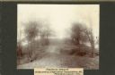
| Description: | View across top of platform mound on the crest of a high hill. Trees are on the left and right. In the background below is the Mississippi River. |
| Date: | 10 16 1910 |
|---|---|
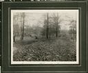
| Description: | View of a linear Indian mound at Big Bend. Two men stand in the background on the left and right among the trees. |

| Date: | 01 25 2015 |
|---|---|
| Description: | Small patches of snow are covering the grass and dead leaves on an American Indian effigy mound. Trees are in the background. |

| Date: | 1944 |
|---|---|
| Description: | Portage County Map. Includes the towns of Eau Plaine, Dewey, Sharon, Alban, Carson, Hull, New Hope, Linwood, Stockton, Amherst, Plover, Grant, Buena Vista,... |
| Date: | 1920 |
|---|---|
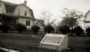
| Description: | Historic site marker to commemorate Man Mound and to mark Man Mound Park. The inscription reads "Man Mound Park. Mound located and platted by W.H. Canfield... |
| Date: | 1930 |
|---|---|
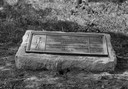
| Description: | View of the panther itaglio effigy mound marker, located on Highway 106 West. The text on the marker reads: "Panther Intaglio Effigy; Panther Type, Length ... |

| Date: | 1936 |
|---|---|
| Description: | View of the panther intaglio effigy mound marker, located on Highway 106 West. The text on the marker reads: "Indian Intaglio Effigy; Panther Type, Length ... |
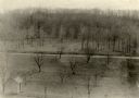
| Date: | 1910 |
|---|---|
| Description: | Elevated view of a double-tailed turtle effigy mound on Observatory Hill on the University of Wisconsin-Madison campus. |
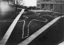
| Date: | |
|---|---|
| Description: | Elevated view of Man Mound outlined in chalk looking south. A road bisects the legs of the effigy mound. A small outbuilding can be seen at left in the for... |
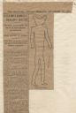
| Date: | 12 28 1906 |
|---|---|
| Description: | Newspaper article about the purchase of land for a park related to Man Mound in Sauk County accompanied by a line drawing of the mound. Article clipped fro... |
| Date: | 05 31 1935 |
|---|---|
| Description: | Students digging into a bird effigy mound on the University of Wisconsin campus on May 31 through June 1, 1935. |

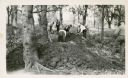
| Date: | 06 1911 |
|---|---|
| Description: | A field party of members of the Wisconsin Archaeological Society visit an effigy mound at Big Bend. The men are dressed in suits and hats. |

| Date: | 06 30 1910 |
|---|---|
| Description: | People gathered for a ceremony at the unveiling of a marker at an eagle effigy mound on the State Hospital Grounds. |

| Date: | 05 04 1915 |
|---|---|
| Description: | Caption reads: "An effigy of the water spirit type found at Clifton, Wis. The outline was whitewashed, the mound being carefully followed where it met the ... |

| For Properties with Human Burial Sites |
|---|
| Do you own a human burial site in Wisconsin? Learn about your rights and responsibilities under state law. |
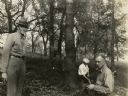
| Date: | |
|---|---|
| Description: | Charles E. Brown (left), directs excavation of a goose effigy mound at the Willow Drive mound group on the University of Wisconsin-Madison campus. |

| Date: | 1839 |
|---|---|
| Description: | A chart showing the geological cross-section and the height above the surrounding landscape of several locations, such as Platte Mound in Wisconsin, and th... |

| Date: | 1927 |
|---|---|
| Description: | Three men and two women sit on top of a mound near Trade Lake. |

| Date: | 1913 |
|---|---|
| Description: | Ink and watercolor on tracing cloth. Shows parts of Green Lake, Princeton, and Brooklyn townships, Indian mound groups, Green Lake, and other significant b... |

| Date: | 1945 |
|---|---|
| Description: | This maps shows roads, railroads, parks, recreational areas, Lake Wingra, Lake Monona, and part of Lake Mendota. The map includes pictorial images that dep... |
If you didn't find the material you searched for, our Library Reference Staff can help.
Call our reference desk at 608-264-6535 or email us at: