 Search: mounds
Filter: Year of 1900-1999
Search: mounds
Filter: Year of 1900-1999

| Date: | 1935 |
|---|---|
| Description: | A man identified only as "Sticky" is posing standing on the lawn in front of a log cabin at Little Norway. He is wearing traditional Norwegian dress with e... |

| Date: | 1969 |
|---|---|
| Description: | A map of Wisconsin from The Atlas of the Eight Counties of Forest, Florence, Iron, Langlade, Lincoln, Oneida, Price, Vilas. The map shows rivers and a vari... |

| Date: | 08 03 1945 |
|---|---|
| Description: | Children leaving the truck hired by the Red Cross Chapter of Mt. Horeb to drive them to a swimming class at the Bluemounds pool. |
| Date: | 06 25 1948 |
|---|---|
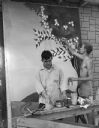
| Description: | Edwin Morgan, at bench, and James Price, shirtless with cigarette in his mouth, are painting scenery for the Crater Players production of "The Drunkard". |
| Date: | 06 29 1948 |
|---|---|
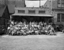
| Description: | Group portrait of 110 Wisconsin State Journal paper carriers taken prior to leaving for Blue Mounds State Park for the annual all-day outing. |

| Date: | 1970 |
|---|---|
| Description: | This pictorial map of Dunn County, Wisconsin, from the 1970s depicts historical events that occurred in the county. It shows cemeteries, churches, schools,... |
| Date: | 1924 |
|---|---|
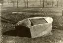
| Description: | A marker showing an Indian Mound in La Crosse. |

| Date: | 1900 |
|---|---|
| Description: | Three men are standing near a man, seen from the rear, on a horse-drawn McCormick binder on the side of a hill. Sheaves of wheat are standing in mounds in ... |

| Date: | 07 25 1958 |
|---|---|
| Description: | View towards the exterior of a two-story addition to Hoyt School (on Regent Street near Hoyt Park). There are mounds of ground rubble near trees, and a car... |

| Date: | 06 01 1983 |
|---|---|
| Description: | Two people are leaning against a railing overlooking at forest. Caption reads: "Rachel Imsland, 25, and Mark Evans, 28, both of Iowa City, Iowa, viewed the... |
| Date: | 1915 |
|---|---|
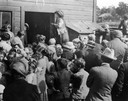
| Description: | Belle Case La Follette, wife of Robert M. La Follette, Sr., addressing a group of farmers during a tour on the Chautauqua circuit during which she frequent... |
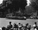
| Date: | 05 29 1948 |
|---|---|
| Description: | Wisconsin Centennial Parade near the Wisconsin State Capitol. The Blue Mounds float depicting Dane County's first settler, Ebenezer Brigham, is coming down... |

| Date: | 06 12 1948 |
|---|---|
| Description: | Champion Gilbert "Gib" Bergdoll (right) of the Koshkonong Mounds Club of Fort Atkinson and runnerup, Norbert "Coley" Griffin of Meadow Springs Club of Jeff... |

| Date: | 07 18 1953 |
|---|---|
| Description: | Unidentified golfer at Koshkonong Mounds Country Club in Fort Atkinson, site of the 31st annual East-Central Wisconsin Golf Association tournament. |

| Date: | 1915 |
|---|---|
| Description: | This 1915 map covers portions of Barron, Chippewa, and Rusk counties in Wisconsin. Shown are the township and range grid, sections, cities and villages, ra... |
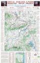
| Date: | 1975 |
|---|---|
| Description: | This map shows points of interest in south central Wisconsin from the Wisconsin Dells and the Baraboo Hills down to Madison and Blue Mounds. Interest point... |

| Date: | 08 03 1945 |
|---|---|
| Description: | A Red Cross instructor with a children's swimming class at the Bluemounds swimming pool. The instructor is George Steiner, assistant principal at Madison W... |

| Date: | 1920 |
|---|---|
| Description: | This 1920 map actually depicts present-day Wyalusing State Park at the confluence of the Mississippi and Wisconsin rivers in the Town of Wyalusing, Grant C... |

| Date: | 1924 |
|---|---|
| Description: | This pictorial map focuses on the Madison Isthmus, Lake Mendota, Lake Monona, Lake Wingra, and shows points of historical interest, buildings, parks, and I... |

| Date: | 1933 |
|---|---|
| Description: | Blue print and blue line print maps that show local streets, Nakoma Country Club, part of Lake Forest, and part of Lake Wingra. A legend is included that s... |
If you didn't find the material you searched for, our Library Reference Staff can help.
Call our reference desk at 608-264-6535 or email us at: