 Search: mounds
Filter: Year of 1900-1999
Filter: Year of 1960-1969
Search: mounds
Filter: Year of 1900-1999
Filter: Year of 1960-1969

| Date: | 07 31 1960 |
|---|---|
| Description: | Landscape view of willow trees in the Valley of the Mounds Creek, along Highway F. |

| Date: | 1969 |
|---|---|
| Description: | A girl is standing high up among a group of stalagmites in the Cave of the Mounds. Another girl is leaning against a railing on the left. |

| Date: | 11 06 1960 |
|---|---|
| Description: | A corner of a cornfield in an early snow. |

| Date: | 07 31 1960 |
|---|---|
| Description: | An abandoned threshing machine rests in a rural field. |

| Date: | 10 1966 |
|---|---|
| Description: | Tall grass grows at the roadside edge of a flat field. |
| Date: | 09 01 1963 |
|---|---|
| Description: | A view of an abandoned log cabin obscured by plants and trees. |
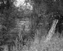
| Date: | 07 31 1960 |
|---|---|
| Description: | Exterior view of a school house near Highway F. A large rock outcropping resides in the schoolyard. |

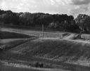
| Date: | 12 01 1962 |
|---|---|
| Description: | A farm road between fields in late sunlight, looking towards Mounds Creek in the vicinity of CTH F. |
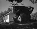
| Date: | 07 31 1960 |
|---|---|
| Description: | A large rock formation in the schoolyard of the Deneen School. A small outbuilding and fence is visible in the background. |

| Date: | 1962 |
|---|---|
| Description: | Elevated view over wooded farmland valley. In the far distance on top of the hill are farm buildings. |

| Date: | 07 31 1960 |
|---|---|
| Description: | View of a tree and mailbox, with a farmhouse behind below road level along a rural highway. There is a hill in the background with trees. |
| Date: | 07 1967 |
|---|---|
| Description: | A country road and electrical lines run through a field of oats. On the left is a road, and a farmhouse is in the background on a hill. |

| Date: | 05 30 1964 |
|---|---|
| Description: | Landscape view from field of a rolling countryside. A small cheese factory resides on a slope, with a tree, a windmill, two cars and a tractor near an outb... |

| Date: | 1969 |
|---|---|
| Description: | A map of Wisconsin from The Atlas of the Eight Counties of Forest, Florence, Iron, Langlade, Lincoln, Oneida, Price, Vilas. The map shows rivers and a vari... |
| Date: | 1963 |
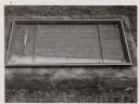
|---|---|
| Description: | The marker notes Man Mound Park by the Wisconsin Archeological Society, Sauk County Historical Society and the Landmark Committee, W.F.W.C. |

| Date: | 01 1969 |
|---|---|
| Description: | A map of Oneida county, which includes a small drawing of a hodag. |

| Date: | 1967 |
|---|---|
| Description: | Stereograph of an elevated view of a farm. A man is sitting on the hill in the foreground with his arm on one knee, gazing at the view. There is a house, p... |

| Date: | 03 31 1965 |
|---|---|
| Description: | Nature view with marshland sedges and rushes in foreground, Lake Kegonsa, and a tree-lined horizon. The newly acquired area consists of marsh, woodland, In... |
If you didn't find the material you searched for, our Library Reference Staff can help.
Call our reference desk at 608-264-6535 or email us at: