Search: mounds

| Date: | 1933 |
|---|---|
| Description: | Blue print and blue line print maps that show local streets, Nakoma Country Club, part of Lake Forest, and part of Lake Wingra. A legend is included that s... |

| Date: | 1864 |
|---|---|
| Description: | This map is pen and watercolor on paper and shows a profile and geological sections of the Spensley Break, James Break, Wisconsin River, and Little Bear Cr... |

| Date: | 09 07 2014 |
|---|---|
| Description: | View from the top of a hill looking out to a valley, with clouds in the blue sky. Trees are framing the view, and in the foreground, a woman, the photograp... |
| Date: | |
|---|---|
| Description: | View of Aztalan State Park site when it was called Aztalan Mound Park. |

| Date: | 1851 |
|---|---|
| Description: | Diagram of an effigy mound in the shape of a cross. |

| Date: | 1873 |
|---|---|
| Description: | A map of the township of Primrose from the "Atlas of Dane County." |
| Date: | 06 1939 |
|---|---|
| Description: | Elevated view of the tourist attraction Little Norway, situated in an idyllic valley, with the stave church in the center and a small house at right. There... |

| Date: | 1948 |
|---|---|
| Description: | The John H. Rountree House, built in 1854. According to "The History of Wisconsin" (Vol. I, 1973), "The rise of the settlement at Platte Mounds was indisso... |

| Date: | 1844 |
|---|---|
| Description: | A hand-colored map and chart showing a geological cross-section from Rockingham, in present-day Scott County, Iowa, through Blue Mounds to the Wisconsin Ri... |
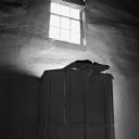
| Date: | 08 2013 |
|---|---|
| Description: | Interior view of a window sitting high up in a white lime-plastered wall, letting light into Hauge Church, a small Lutheran church built in 1852 by Norwegi... |

| Date: | 1864 |
|---|---|
| Description: | This map is pen and watercolor on paper and shows a profile and geological sections of the East Blue Mound Break, Blue Mound Creek, Black Earth River, and ... |

| Date: | 08 1955 |
|---|---|
| Description: | Eight Wisconsin State Journal carrier boys around a picnic table enjoying root beer and apples in the shade of a grove. They are (left to right): Ri... |
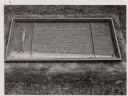
| Date: | 1963 |
|---|---|
| Description: | The marker notes Man Mound Park by the Wisconsin Archeological Society, Sauk County Historical Society and the Landmark Committee, W.F.W.C. |

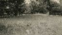
| Date: | |
|---|---|
| Description: | A large burial mound near the south side of Governor Nelson State Park. |

| Date: | 06 30 1939 |
|---|---|
| Description: | A drawing of a lizard-shaped Indian mound at Hudson Park. |

| Date: | 07 13 1955 |
|---|---|
| Description: | Mrs. Charles I. Brigham (left), and her daughter-in-law, Mrs. Charles Brigham, Jr., with her children Mark, Jonathan, and Elizabeth, standing and reading t... |

| Date: | 1930 |
|---|---|
| Description: | Poppies are blooming in a large field with a hill in the background. The photographer identifies the hill as a shell mound. The shell mound is likely the l... |
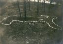
| Date: | 1914 |
|---|---|
| Description: | Deer or rabbit effigy mound outlined with lime (ca. 800-1100 A.D.), at the McConnell mound group. |
| Date: | |
|---|---|
| Description: | An animal effigy burial mound at the Williams South mound group on the north shore of Lake Kegonsa. |
If you didn't find the material you searched for, our Library Reference Staff can help.
Call our reference desk at 608-264-6535 or email us at: