 Search: mounds

| Date: | 05 04 1915 |
|---|---|
| Description: | Caption reads: "An effigy of the water spirit type found at Clifton, Wis. The outline was whitewashed, the mound being carefully followed where it met the ... |
| Date: | 05 1833 |
|---|---|
| Description: | Painting of Black Hawk by Robert M. Sully. Black Hawk, a Native American Sauk warrior and leader, sought to attack and drive out the settlers in the Blue M... |

| Date: | 1916 |
|---|---|
| Description: | Winter scene with man walking down cleared train tracks, probably the Soo Line, next to man-sized drifts of snow, with a dog on the top of a drift. Between... |
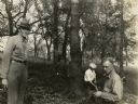
| Date: | |
|---|---|
| Description: | Charles E. Brown (left), directs excavation of a goose effigy mound at the Willow Drive mound group on the University of Wisconsin-Madison campus. |

| Date: | 1839 |
|---|---|
| Description: | A chart showing the geological cross-section and the height above the surrounding landscape of several locations, such as Platte Mound in Wisconsin, and th... |

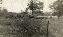
| Date: | 1927 |
|---|---|
| Description: | Three men and two women sit on top of a mound near Trade Lake. |

| Date: | 1913 |
|---|---|
| Description: | Ink and watercolor on tracing cloth. Shows parts of Green Lake, Princeton, and Brooklyn townships, Indian mound groups, Green Lake, and other significant b... |

| Date: | 1967 |
|---|---|
| Description: | Stereograph of an elevated view of a farm. A man is sitting on the hill in the foreground with his arm on one knee, gazing at the view. There is a house, p... |

| Date: | 1945 |
|---|---|
| Description: | This maps shows roads, railroads, parks, recreational areas, Lake Wingra, Lake Monona, and part of Lake Mendota. The map includes pictorial images that dep... |

| Date: | 1864 |
|---|---|
| Description: | This map shows locations of quarries, sink holes, creeks, springs, rivers, houses, forts, and roads. The upper right corner and right margin includes anno... |

| Date: | 09 21 1945 |
|---|---|
| Description: | Elevated view over automobiles parked in the foreground and across fields towards a farm, which has several buildings, including a large silo. Caption read... |
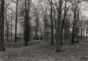
| Date: | 1930 |
|---|---|
| Description: | A linear burial mound and historic marker at the University Ridge mound group on the University of Wisconsin-Madison campus. The mound group was eventually... |
| Date: | 1938 |
|---|---|
| Description: | A field party lead by Charles E. Brown prepare to excavate the Heim effigy mound. The effigy, shaped like a fox or wolf, has been outlined by stakes. The m... |

| Date: | 03 31 1965 |
|---|---|
| Description: | Nature view with marshland sedges and rushes in foreground, Lake Kegonsa, and a tree-lined horizon. The newly acquired area consists of marsh, woodland, In... |
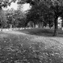
| Date: | 10 2013 |
|---|---|
| Description: | A grove of trees growing behind a line of gravestones at Forest Hill Cemetery, and what may be an effigy mound. Fallen leaves are on the grass. |

| Date: | 1845 |
|---|---|
| Description: | Map of Wisconsin, including lower western border with Iowa, southern border along Illinois, eastern shoreline of Lake Michigan, and northern area along Wis... |

| Date: | 07 19 1948 |
|---|---|
| Description: | The higher antenna of the WIBA tower and transmitting station increased the power of the station for the newly operational FM transmission at the Blue Moun... |
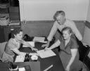
| Date: | 06 13 1952 |
|---|---|
| Description: | Dane County marriage license clerk Mercedes Dufour, (left), issues a license to Lucille A. Roth and Amos M. Skogen for their leap year wedding at the East ... |

| Date: | 1864 |
|---|---|
| Description: | Map showing locations of quarries, sink holes, creeks, springs, rivers, houses, forts, and roads. The map appears to have been drawn on to of a plat map of... |
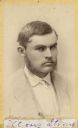
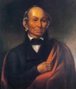
| Date: | |
|---|---|
| Description: | Carte-de-visite portrait of Moses Strong, a Wisconsin archaeologist who served as Lapham's assistant. His most important article was titled, "Prehistoric M... |
If you didn't find the material you searched for, our Library Reference Staff can help.
Call our reference desk at 608-264-6535 or email us at: