 Search: paper
Search: industry
Filter: Subject of lakes
Search: paper
Search: industry
Filter: Subject of lakes
| Date: | |
|---|---|
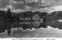
| Description: | Columbia Mill, established in 1827, is shown surrounded by a landscape featuring a lake and wooded mountain. The mill is the site where the first successfu... |
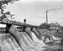
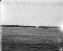
| Date: | 1927 |
|---|---|
| Description: | View across lower section of dam at Cornell Wood Products Company. In the background are factory buildings, a tall smokestack, and a water tower. |

| Date: | 1925 |
|---|---|
| Description: | Shows buildings, piers, winter and summer levels, and resort lands. Depths shown by isolines. Relief shown by contours. From the E.P. Sherry papers relatin... |
| Date: | 05 05 1963 |
|---|---|
| Description: | View across water towards two fishing boats moored at a dock. |

| Date: | 1910 |
|---|---|
| Description: | View across water towards the Lyle Mine and Ranier on the shoreline of Rainy Lake. |

| Date: | 1903 |
|---|---|
| Description: | This map is ink on printed paper reading: "standard profile plate." "Surveyed Oct. 15, platted Dec. 15, 1903 ; surveyed May 9, platted Dec. 9." |

| Date: | 1910 |
|---|---|
| Description: | A view across water towards the Rainy Lake shoreline, which includes Lyle Mine and Ranier. |

| Date: | 1900 |
|---|---|
| Description: | This map shows a paper city located on Swan Lake in Columbia County. It includes lot and block numbers, two public squares, and two little lakes of "good w... |
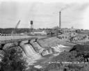
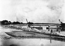
| Date: | 1927 |
|---|---|
| Description: | Elevated view over dam of the site of the Cornell Wood Products Company. On the opposite shoreline is a pulpwood stacker, tall smokestack, water tower, and... |
| Date: | 1910 |
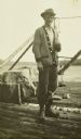
|---|---|
| Description: | Canadian Fire Ranger J.B. MacDonald standing on the dock by Fall Lake. |

| Date: | 1880 |
|---|---|
| Description: | This map is pen-and-ink on paper. The map shows buildings, trees, and water and gas pipes, relief is shown by contours. The back of the map reads: "Univers... |
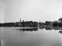
| Date: | 06 1900 |
|---|---|
| Description: | View across Lake La Belle toward lakeside factories, residences, and churches. |
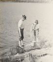
| Date: | 1914 |
|---|---|
| Description: | Howard and Jack Greene doing laundry in Lake McFarland. |
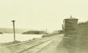
| Date: | 1911 |
|---|---|
| Description: | A view down railroad tracks toward a water tank. Lake Windigoostigwan is on the left. |
| Date: | 1907 |
|---|---|
| Description: | A steam-powered dredge anchored in Monona Bay is filling in Brittingham Park. |
| Date: | 1898 |
|---|---|
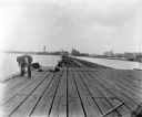
| Description: | Fishermen fishing off of a long pier. Industrial buildings are across the water in the background. |
| Date: | 1927 |
|---|---|
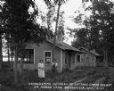
| Description: | Two women pose outside their lakefront cabin. |

| Date: | 1910 |
|---|---|
| Description: | Bill Marr, on the left, and Howard "Dad" Greene washing their clothes with soap on a rock by the lake. |
| Date: | 07 07 1898 |
|---|---|
| Description: | View across water of Sturgeon Bay. In the far distance are lighthouses, buildings, and barges along the shoreline. |
If you didn't find the material you searched for, our Library Reference Staff can help.
Call our reference desk at 608-264-6535 or email us at:
