 Search: paper
Search: industry
Filter: Subject of marshes
Search: paper
Search: industry
Filter: Subject of marshes

| Date: | 1836 |
|---|---|
| Description: | This map is pen-and-ink on paper and shows marshlands, rivers, creeks, a quarry, and a few roads. |
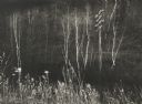
| Date: | 11 1961 |
|---|---|
| Description: | Telephone pole among marsh grasses and bare birch trees near the Spring Green Bridge. |

| Date: | 1900 |
|---|---|
| Description: | This photostat of a manuscript map originally drawn in 1829 shows landownership, buildings, including Fort Howard and U.S. sawmill, swamps, public barns an... |

| Date: | |
|---|---|
| Description: | Elevated view from bluff overlooking the railroad tracks and yard along the Mississippi River. A group of men are gathered on the track near stacks of lumb... |
If you didn't find the material you searched for, our Library Reference Staff can help.
Call our reference desk at 608-264-6535 or email us at:
