Search: paper
Search: industry
Filter: Subject of municipal services
Search: paper
Search: industry
Filter: Subject of municipal services

| Date: | 1903 |
|---|---|
| Description: | This map is ink on printed paper reading: "standard profile plate." "Surveyed Oct. 15, platted Dec. 15, 1903 ; surveyed May 9, platted Dec. 9." |
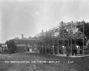
| Date: | 1929 |
|---|---|
| Description: | Power plant machinery in the Wisconsin Power and Light Company substation. |

| Date: | 1963 |
|---|---|
| Description: | Sand and gravel pit used by the Dane County highway department as a source of supply. |
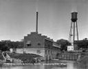
| Date: | 1924 |
|---|---|
| Description: | The Municipal Light and Power Plant and water tower seen from across a pond. |

| Date: | 1880 |
|---|---|
| Description: | This map is pen-and-ink on paper. The map shows buildings, trees, and water and gas pipes, relief is shown by contours. The back of the map reads: "Univers... |
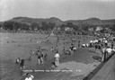
| Date: | 1930 |
|---|---|
| Description: | The municipal sand-bottomed swimming pool was a popular spot to cool off in the summer months. |

| Date: | 1976 |
|---|---|
| Description: | An older man is standing in an office, possibly a weigh station of the Philadelphia Street Department. He is at a bench with papers and various office supp... |

| Date: | 1969 |
|---|---|
| Description: | A manhole cover in the street with steam coming through its openings. |

| Date: | 1969 |
|---|---|
| Description: | A construction worker wearing a red hard hat crouches next to an open manhole in the street. |

| Date: | 1945 |
|---|---|
| Description: | Exterior view of the stone-walled headquarters building of the Water Regulatory Board located within a grove of trees. According to text included with the ... |

| Date: | 10 20 1954 |
|---|---|
| Description: | Governor Walter Kohler being is presented with a 147-foot petition bearing signatures of 5,000 area residents seeking to ban the diversion of sewage from t... |
If you didn't find the material you searched for, our Library Reference Staff can help.
Call our reference desk at 608-264-6535 or email us at: