Search: paper
Search: industry
Filter: Subject of railroads
Search: paper
Search: industry
Filter: Subject of railroads
| Date: | |
|---|---|
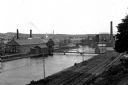
| Description: | View of the First Level Canal lined with industrial buildings featuring a paper mill,founded in 1882, on the right. A sign on the buildings reads, "Whitin... |

| Date: | 1881 |
|---|---|
| Description: | Bird's-eye map of Marinette, with insets. |
| Date: | 02 02 1988 |
|---|---|
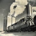
| Description: | Two Wisconsin Central Railroad locomotives near the Consolidated Papers pulpmill at Wisconsin Rapids. Snow is on the ground, and heavy smoke is coming out ... |
| Date: | |
|---|---|
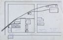
| Description: | Line drawing on tissue paper showing the layout of the Gisholt plant buildings over two blocks at East Washington and Baldwin Streets. Shows streets and ra... |

| Date: | 1900 |
|---|---|
| Description: | Shows limits of drainage basin, dams, rapids, roads, and railroads in parts of Iron and Vilas Counties, Wisconsin. From the E.P. Sherry papers relating to ... |

| Date: | 1855 |
|---|---|
| Description: | This map is ink, pen, and watercolor on paper and shows plat of the town, local streets, lots by number, U.S. subdivisions in red lines, Mineral Point Rail... |

| Date: | 1883 |
|---|---|
| Description: | Bird's-eye map of Superior, county seat of Douglas County, on the shores of Lake Superior, with insets of points of interest. |
| Date: | 05 1902 |
|---|---|
| Description: | Alexander Krueger and Ernst Goetsch standing along a railroad track leading to a sawmill. The mill stais at the end of the tracks, which is lined with tree... |

| Date: | 11 1923 |
|---|---|
| Description: | This map shows buildings, lots, utilities, and original plat and present locations of railroads. Portions of the map are shown in red, brown, yellow, blue,... |

| Date: | 1925 |
|---|---|
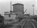
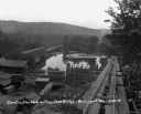
| Description: | Railroad tank cars on railroad tracks outside the plant. There are two large round storage tanks behind the tank cars. |

| Date: | 1893 |
|---|---|
| Description: | Bird’s-eye view of Depere looking North. Includes illustrations and an index to points of interest. |

| Date: | 1972 |
|---|---|
| Description: | A topographic map of the Blackwell quadrangle. |
| Date: | |
|---|---|
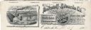
| Description: | Memohead of the Buckstaff-Edwards Company of Oshkosh, Wisconsin, manufacturers of coffins and caskets and wholesale dealers in caskets and undertaking supp... |
| Date: | 09 15 1946 |
|---|---|
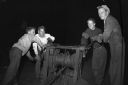
| Description: | Four workers operating an "ancient" winch. Part of a series on working conditions aboard Lake Michigan railroad car ferries. Ferry workers belonged to the ... |

| Date: | 1858 |
|---|---|
| Description: | An ink on paper map of Milwaukee County and the eastern portion of Waukesha County that shows the townships of Oak Creek, Franklin, Greenfield, Wauwatosa, ... |
| Date: | 08 29 1930 |
|---|---|
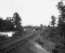
| Description: | View from top of new bridge of construction grounds at the bridge site. There are cars carrying building materials on the railroad tracks by the Bridgeport... |
If you didn't find the material you searched for, our Library Reference Staff can help.
Call our reference desk at 608-264-6535 or email us at: