Visit our other Wisconsin Historical Society websites!
 Search: paper
Search: industry
Filter: Subject of roads
Search: paper
Search: industry
Filter: Subject of roads

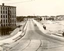
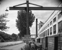
| Date: | 1960 |
|---|---|
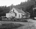
| Description: | View across road towards the Mosinee Paper Company. |
| Date: | |
|---|---|
| Description: | View from other side of bridge toward the paper mill, with a bridge and road to the left. A horse-drawn vehicle is on the bridge. Caption reads: "Paper Mil... |
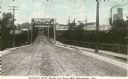
| Date: | 1905 |
|---|---|
| Description: | View down center of the Davenport Street Bridge with a paper mill in the distance on the right. Caption reads: "Davenport Street Bridge and Paper Mill, Rhi... |

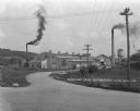
| Date: | 1907 |
|---|---|
| Description: | Text on front reads: "Paper Mill Road, Showing Plover Paper Mill, Stevens Point, Wis." View of an unpaved road leading to a paper mill on the Wisconsin Riv... |

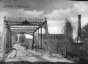
| Date: | 1917 |
|---|---|
| Description: | View of a road bridge crossing the Menominee River. There is a paper mill on the opposite shoreline. Caption reads: "Hattie Street Bridge and M. & M. Paper... |
| Date: | 1925 |
|---|---|
| Description: | Exterior of the Nestle Food Condensery plant. |
| Date: | 1935 |
|---|---|
| Description: | View towards bridge. The Nicolet Paper Company is on the left. |
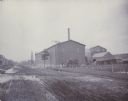
| Date: | 1880 |
|---|---|
| Description: | View of the Wausau Sand Paper Company, about 1903-1905, at Second and Thomas streets. |
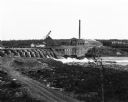
| Date: | |
|---|---|
| Description: | Elevated view across dirt road of a paper mill on the shore of the Chippewa River next to a concrete dam. The mill has a tall smokestack. On the far shorel... |
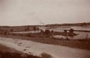
| Date: | 06 1898 |
|---|---|
| Description: | The Fox River seen from the hill behind the Catholic Church and looking toward the combined locks. In the distance is a paper mill. |

| Date: | 1922 |
|---|---|
| Description: | Exterior of the Chaseburg Cooperative Creamery and an attached secondary building. |

| Date: | 1921 |
|---|---|
| Description: | The site of the Klindt-Geiger Canning Company, operated from 1893 to 1950. The factory features a water tower. |

| Date: | 07 1870 |
|---|---|
| Description: | This map of Ironton is pen-and-ink on paper and shows lots and block numbers, mill, foundry buildings, limestone quarry, iron mine, and roads. Relief is sh... |

| Date: | 1836 |
|---|---|
| Description: | This map is pen-and-ink on paper and shows marshlands, rivers, creeks, a quarry, and a few roads. |

| Date: | 1924 |
|---|---|
| Description: | Exterior view from road of the Valecia Evaporated Milk Company, a condensery. |
| Date: | 08 05 1962 |
|---|---|
| Description: | Exterior view of Riverside Paper Corporation mill. On the left is a road along a river, and on the right are railroad tracks along the mill. A sign in the ... |
If you didn't find the material you searched for, our Library Reference Staff can help.
Call our reference desk at 608-264-6535 or email us at: