 Search: paper
Search: industry
Filter: Subject of streams
Search: paper
Search: industry
Filter: Subject of streams

| Date: | 1947 |
|---|---|
| Description: | An ink on paper, hand-drawn map of Jefferson County, Wisconsin, that identifies named hills, other points of interest, and the Lake Mills moraine system in... |

| Date: | 1972 |
|---|---|
| Description: | A topographic map of the Blackwell quadrangle. |

| Date: | 1858 |
|---|---|
| Description: | An ink on paper map of Milwaukee County and the eastern portion of Waukesha County that shows the townships of Oak Creek, Franklin, Greenfield, Wauwatosa, ... |
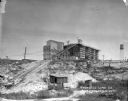
| Date: | 1924 |
|---|---|
| Description: | View from low section of quarry towards the processing plant up a steep rise. Tracks for hauling limestone are on the left near small sheds and a marshy ar... |
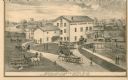
| Date: | 1873 |
|---|---|
| Description: | A print depicts activity around the three-story, wood frame Geneva Flouring Mills. Horse-drawn wagons, pedestrians, and a boy rolling a hoop create a busy ... |
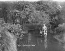
| Date: | |
|---|---|
| Description: | A man holds the hands of two children, all posing standing in the middle of a stream. The two children wear swimming suits, and the man has his pants rolle... |
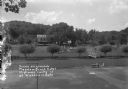
| Date: | |
|---|---|
| Description: | Elevated view over the volleyball court of the grounds at the Meadow Brook Hotel. A footbridge is across a stream on the right. A group of people are stand... |
If you didn't find the material you searched for, our Library Reference Staff can help.
Call our reference desk at 608-264-6535 or email us at:
