Search: peshtigo
Filter: Categories of Wisconsin Historical Images
Filter: Subject of rivers
Search: peshtigo
Filter: Categories of Wisconsin Historical Images
Filter: Subject of rivers

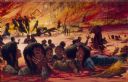
| Date: | 1871 |
|---|---|
| Description: | Drawing of the Peshtigo Fire, showing people seeking refuge in the Peshtigo River. |
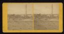
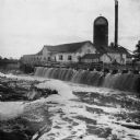
| Date: | 1871 |
|---|---|
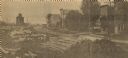
| Description: | Ruins of building showing smokestack still standing after the Peshtigo fire. A group of men are standing on the left. |
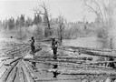
| Date: | 1900 |
|---|---|
| Description: | Log pond with two lumberjacks walking on the floating logs and sorting them in the Peshtigo River area. |

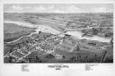
| Date: | 09 1871 |
|---|---|
| Description: | Bird's-eye view of Peshtigo, before it was destroyed by fire on the night of October 8, 1871. |

| Date: | |
|---|---|
| Description: | View across water towards the Badger Paper Mills, founded by E.A. Meyer. Caption reads: "Badger Paper Mills, Peshtigo, Wis." |
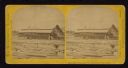
| Date: | 1890 |
|---|---|
| Description: | View of the Peshtigo Company sawmill including the old wooden dam in the foreground. There are logs in the water on the left. |

| Date: | |
|---|---|
| Description: | Map of the district of the Peshtigo fire, approximately 1,280,000 acres, in Wisconsin and Upper Michigan. |
| Date: | 1867 |
|---|---|
| Description: | Mill dam and sash factory. "The Northwester Gateway. Excursion to Lake Superior, June 1867. Photographed and Published by J. Carbutt, 131 Lake St., Chicago... |

| Date: | |
|---|---|
| Description: | View over large rocks towards the Peshtigo River in Goodman Park. |

| Date: | 12 27 1925 |
|---|---|
| Description: | View looking down towards a young woman walking across a bridge. Caption reads: "Cable Bridge across Peshtigo River (Marinette County). Josephine Schaffer-... |

| Date: | 1912 |
|---|---|
| Description: | This blueprint manuscript map shows selected buildings, roads, and the Peshtigo River. |

| Date: | |
|---|---|
| Description: | This 19th century manuscript map shows the southeastern portion of the Town of Stephenson in Marinette County, Wisconsin. Sections, lakes, and streams are ... |
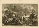
| Date: | 11 25 1871 |
|---|---|
| Description: | Engraved view of Peshtigo Fire showing people trying to escape the flames by boat and on horseback. A team of cattle also seek refuge and several birds tak... |

| Date: | 1851 |
|---|---|
| Description: | This manuscript map of the southern portion of the Town of Porterfield, Marinette County, Wisconsin, shows sections and land ownership. The Menominee River... |

| Date: | 1887 |
|---|---|
| Description: | This manuscript map of the southern portion of the Town of Porterfield, Marinette County, Wisconsin, shows sections and land ownership. The Menominee River... |
| Date: | 1963 |
|---|---|
| Description: | H.P. Christ Feed Mill. The first building across the street is the Atlas Hotel which was located at the site of the present Milo Howarth senior home. Other... |

| Date: | 1905 |
|---|---|
| Description: | Loggers known as "river pigs" round up stray logs with pikes and peaveys at Place's Rapids. |
If you didn't find the material you searched for, our Library Reference Staff can help.
Call our reference desk at 608-264-6535 or email us at: