 Search: places
Filter: Categories of Wisconsin Historical Images
Filter: Type of Map or Atlas
Search: places
Filter: Categories of Wisconsin Historical Images
Filter: Type of Map or Atlas

| Date: | 1956 |
|---|---|
| Description: | This maps shows voting precincts and polling places as well as wards. Streets and the Sheboygan River are labeled. The bottom right of the map features a l... |

| Date: | 1955 |
|---|---|
| Description: | This map shows wards and precincts and includes list of polling places by ward and precinct, and list of State Assembly districts. |

| Date: | 1891 |
|---|---|
| Description: | This maps has an index of depots, hotels, prominent institutions and buildings, churches, and places of amusement. The map was removed from an unidentified... |
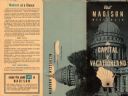
| Date: | |
|---|---|
| Description: | The cover of a map which is titled: "Visit Madison Wisconsin the Capital of Vacationland". The cover lists various places to visit in the city. |

| Date: | 1906 |
|---|---|
| Description: | This map shows shows streets, subdivisions, railroads, places of interest including the State Capitol, the University of Wisconsin, Camp Randall, Henry Vil... |

| Date: | 1965 |
|---|---|
| Description: | This map shows wards, schools and public buildings, and polling places. The map includes a street index. Lac La Belle, Fowler Lake, and Oconomowoc Lake are... |

| Date: | 1907 |
|---|---|
| Description: | Shows public buildings, hotels, fraternity houses, and private houses. Index of fraternities and sororities, residences, public buildings, hotels, places o... |

| Date: | 1945 |
|---|---|
| Description: | This map shows wards and precincts and includes a list of polling places by ward and precinct. The map reads: "Keep this Map . . . It Gives the Location of... |

| Date: | 1948 |
|---|---|
| Description: | This map shows wards and precincts and includes a list of polling places by ward and precinct. The map reads: "Keep this Map . . . It Gives the Location of... |

| Date: | 1976 |
|---|---|
| Description: | This map includes an index of streets, government and historic buildings, hospitals, schools, places of recreation, churches, cemeteries, and other miscell... |

| Date: | 1948 |
|---|---|
| Description: | This map shows a list of polling places by ward and precinct in the left margin, a list of assembly districts, and additional handwritten notes. Lake Michi... |

| Date: | 1961 |
|---|---|
| Description: | This is a photocopy of a map in blue line print that shows streets and places of interest. Inscribed in pen, at the bottom of the map, reads: "Sen. Zaborsk... |
| Date: | 1999 |
|---|---|
| Description: | This map shows the best places to view bald eagles and areas to avoid when watching for eagles. The back of the map includes text and illustrations. |
| Date: | 1974 |
|---|---|
| Description: | This map of Milwaukee shows forty landmark buildings located and identified, including those on the National Register of Historic Places and the Historic A... |

| Date: | 1941 |
|---|---|
| Description: | This 1941 tourist map of Washington Island, Wisconsin, shows points of interest and places of business. Some information is shown pictorially. Rock, Hog, D... |

| Date: | 1989 |
|---|---|
| Description: | This pictorial map shows the Sheboygan river, businesses with phone numbers, historical buildings, other places of interest, and includes a brief history o... |

| Date: | 1923 |
|---|---|
| Description: | This map shows counties, roads, Lake Superior, Lake Michigan, and portions of surrounding states. Included is an index to cities, villages and other places... |
| Date: | 1900 |
|---|---|
| Description: | This map shows the distances and land use and type along the road from Green Bay to Racine. A few places are labeled, including Devil River, Sheboygan Rive... |

| Date: | 1941 |
|---|---|
| Description: | This pictorial map of Wisconsin with historical text highlights the history of the state and identifies places of interest, Indian villages, missions, trad... |

| Date: | 1904 |
|---|---|
| Description: | A brochure for the lake region of north-eastern Illinois and south-eastern Wisconsin providing information on summer activities and places to stay in the a... |
If you didn't find the material you searched for, our Library Reference Staff can help.
Call our reference desk at 608-264-6535 or email us at: