 Search: places
Filter: Categories of Wisconsin Historical Images
Filter: Subject of transportation
Search: places
Filter: Categories of Wisconsin Historical Images
Filter: Subject of transportation

| Date: | 1956 |
|---|---|
| Description: | This maps shows voting precincts and polling places as well as wards. Streets and the Sheboygan River are labeled. The bottom right of the map features a l... |

| Date: | 1885 |
|---|---|
| Description: | Elevated view of Shell Lake before a fire on December 3, 1889 which swept Main Street and destroyed more than twenty business places. |

| Date: | 1891 |
|---|---|
| Description: | This maps has an index of depots, hotels, prominent institutions and buildings, churches, and places of amusement. The map was removed from an unidentified... |
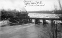
| Date: | 04 04 1913 |
|---|---|
| Description: | Elevated view of the Soo Line train crossing a bridge over the Black River near Withee. The three x's indicate places where the bridge had been damaged by ... |

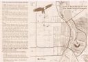
| Date: | 1906 |
|---|---|
| Description: | This map shows shows streets, subdivisions, railroads, places of interest including the State Capitol, the University of Wisconsin, Camp Randall, Henry Vil... |

| Date: | 1965 |
|---|---|
| Description: | This map shows wards, schools and public buildings, and polling places. The map includes a street index. Lac La Belle, Fowler Lake, and Oconomowoc Lake are... |

| Date: | 07 30 1948 |
|---|---|
| Description: | E.T. McQueen, AAA field reporter, who inspects sleeping accommodations and eating places for the AAA Accommodations Directory, issued annually. |

| Date: | 1907 |
|---|---|
| Description: | Shows public buildings, hotels, fraternity houses, and private houses. Index of fraternities and sororities, residences, public buildings, hotels, places o... |

| Date: | 1948 |
|---|---|
| Description: | This map shows wards and precincts and includes a list of polling places by ward and precinct. The map reads: "Keep this Map . . . It Gives the Location of... |

| Date: | 1976 |
|---|---|
| Description: | This map includes an index of streets, government and historic buildings, hospitals, schools, places of recreation, churches, cemeteries, and other miscell... |

| Date: | 1948 |
|---|---|
| Description: | This map shows a list of polling places by ward and precinct in the left margin, a list of assembly districts, and additional handwritten notes. Lake Michi... |

| Date: | 1961 |
|---|---|
| Description: | This is a photocopy of a map in blue line print that shows streets and places of interest. Inscribed in pen, at the bottom of the map, reads: "Sen. Zaborsk... |
| Date: | 1999 |
|---|---|
| Description: | This map shows the best places to view bald eagles and areas to avoid when watching for eagles. The back of the map includes text and illustrations. |
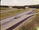
| Date: | 1965 |
|---|---|
| Description: | At many places in Wisconsin, the Interstate Highway is divided by a wide median strip that provides a scenic view for the motorist. This photograph shows ... |

| Date: | 06 22 1936 |
|---|---|
| Description: | A man stands beside an International C-30 truck owned by the Southern Canada Power Company and places an object into a side compartment. There is a "Danger... |

| Date: | 1947 |
|---|---|
| Description: | A man takes bales of hay from a wheeled cart and places them in a wooden livestock feeder. Farm buildings and a herd of cows are behind the man. |

| Date: | 11 03 1941 |
|---|---|
| Description: | A factory worker places charges into an electrically controlled draw furnace at International Harvester's Canton Works. Original caption reads: "Shell Pack... |

| Date: | 1989 |
|---|---|
| Description: | This pictorial map shows the Sheboygan river, businesses with phone numbers, historical buildings, other places of interest, and includes a brief history o... |

| Date: | 1923 |
|---|---|
| Description: | This map shows counties, roads, Lake Superior, Lake Michigan, and portions of surrounding states. Included is an index to cities, villages and other places... |

| Date: | 1942 |
|---|---|
| Description: | Annabel Nelson places three rubber toys on a scale, presumably to donate them to the war effort, while F.E. Williams looks on. The two crouch on the groun... |
If you didn't find the material you searched for, our Library Reference Staff can help.
Call our reference desk at 608-264-6535 or email us at: