 Search: places
Filter: Categories of Wisconsin Historical Images
Search: places
Filter: Categories of Wisconsin Historical Images
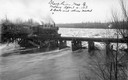
| Date: | 04 04 1913 |
|---|---|
| Description: | Elevated view of the Soo Line train crossing a bridge over the Black River near Withee. The three x's indicate places where the bridge had been damaged by ... |
| Date: | |
|---|---|
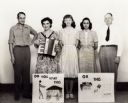
| Description: | Highlander Chautauqua route traveling group that went to North Carolina and other places during the `40's. Myles and Zilphia Horton, far left. Posters re... |
| Date: | 11 16 1936 |
|---|---|
| Description: | A man places a milk can into a McCormick-Deering 6-can milk cooler on the farm of Mrs. Joe Schmidt. |

| Date: | |
|---|---|
| Description: | Black and white postcard of a rock spire with four men posing in various places. Trees are in the background. Text at foot reads: "Rocks, Camp Douglas." |

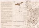
| Date: | 1906 |
|---|---|
| Description: | This map shows shows streets, subdivisions, railroads, places of interest including the State Capitol, the University of Wisconsin, Camp Randall, Henry Vil... |

| Date: | 1965 |
|---|---|
| Description: | This map shows wards, schools and public buildings, and polling places. The map includes a street index. Lac La Belle, Fowler Lake, and Oconomowoc Lake are... |

| Date: | 01 10 1966 |
|---|---|
| Description: | Gail Lukas' hair stands on end when she places her hand on a Van de Graalf generator in a demonstration by the Atomic Energy Commission for junior high sch... |
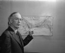
| Date: | 09 20 1947 |
|---|---|
| Description: | James L. Clark, Madison city health inspector, shown pointing to a map of Madison marked with X's signifying places with rat infestation. |
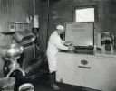
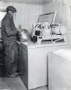
| Date: | 11 24 1936 |
|---|---|
| Description: | Clifford C. Ball places a milk can into a McCormick-Deering 6-can milk cooler. A cream separator stands against the wall to the left. |
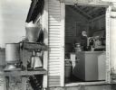
| Date: | 11 03 1936 |
|---|---|
| Description: | A man places a milk can into a cooler housed in a shed. More milk cans and pails are stored on a wooden shelf outside the shed. |

| Date: | 07 30 1948 |
|---|---|
| Description: | E.T. McQueen, AAA field reporter, who inspects sleeping accommodations and eating places for the AAA Accommodations Directory, issued annually. |

| Date: | 09 30 1949 |
|---|---|
| Description: | Maple Bluff fire chief Lawrence Nielsen places the first official dial call on Madison's new 100 percent dial phone service. |

| Date: | 1944 |
|---|---|
| Description: | A woman in a white dress, probably a nurse or volunteer, places a container into a "Tomac Plasma Bank," a refrigeration unit developed by International Har... |

| Date: | 1907 |
|---|---|
| Description: | Shows public buildings, hotels, fraternity houses, and private houses. Index of fraternities and sororities, residences, public buildings, hotels, places o... |

| Date: | 1945 |
|---|---|
| Description: | This map shows wards and precincts and includes a list of polling places by ward and precinct. The map reads: "Keep this Map . . . It Gives the Location of... |

| Date: | 1948 |
|---|---|
| Description: | This map shows wards and precincts and includes a list of polling places by ward and precinct. The map reads: "Keep this Map . . . It Gives the Location of... |

| Date: | 1976 |
|---|---|
| Description: | This map includes an index of streets, government and historic buildings, hospitals, schools, places of recreation, churches, cemeteries, and other miscell... |

| Date: | 1948 |
|---|---|
| Description: | This map shows a list of polling places by ward and precinct in the left margin, a list of assembly districts, and additional handwritten notes. Lake Michi... |

| Date: | 1961 |
|---|---|
| Description: | This is a photocopy of a map in blue line print that shows streets and places of interest. Inscribed in pen, at the bottom of the map, reads: "Sen. Zaborsk... |
| Date: | 1999 |
|---|---|
| Description: | This map shows the best places to view bald eagles and areas to avoid when watching for eagles. The back of the map includes text and illustrations. |
If you didn't find the material you searched for, our Library Reference Staff can help.
Call our reference desk at 608-264-6535 or email us at: