 Search: public
Filter: Type of Map or Atlas
Filter: Creator Name of Unknown
Search: public
Filter: Type of Map or Atlas
Filter: Creator Name of Unknown
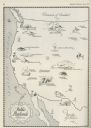
| Date: | 06 1930 |
|---|---|
| Description: | A map of the western states showing "public playlands," mostly national parks. |

| Date: | 1854 |
|---|---|
| Description: | A sketch of the public surveys of Wisconsin and territory of Minnesota. |

| Date: | 1905 |
|---|---|
| Description: | This blueprint map shows rivers, land parcels, and streets. It also highlights selected public and industrial buildings. |

| Date: | 1936 |
|---|---|
| Description: | These two maps of the Town of Conover, Vilas County, Wisconsin, show private land holdings of a section or more as of 1927 and public lands in 1936. Acreag... |

| Date: | 1975 |
|---|---|
| Description: | This map shows nature trails, public attractions, public hunting and fishing grounds, dams, waysides, lakes, highways, and roads. The upper right corner in... |

| Date: | 2004 |
|---|---|
| Description: | This map shows ATMs, houses of worship, hotels, parking ramps, public parking, union cab stands, bus stops, business district, parks and public areas, gove... |

| Date: | 1850 |
|---|---|
| Description: | This map of Cassville shows plat of the town, roads, landings and public wharfs and the Mississippi River. |

| Date: | 1874 |
|---|---|
| Description: | Bird's-eye map of Lodi, with inset of Public School. Includes index of churches and points of interest. |

| Date: | 1850 |
|---|---|
| Description: | This map of Geneva shows lots and acreages, reserved land, and public squares. Streets and Lake Geneva are labeled. The map includes manuscript annotations... |

| Date: | 1900 |
|---|---|
| Description: | This map includes an index of streets and schools, and shows parks and public lands, as well as industrial sites. |

| Date: | 1925 |
|---|---|
| Description: | This map shows the public schools and their school districts. The bottom of the map reads:" Old buildings and sites in red. New buildings and sites in blac... |

| Date: | 1882 |
|---|---|
| Description: | This map is ink and watercolor on paper and shows numbered plots, the public square, streets, Lake St. Croix and the Mississippi River. |

| Date: | 1931 |
|---|---|
| Description: | This map of Ashland shows roads, railroads, and local businesses. The map reads: "Showing streets and roads open to the public Oct. 1, 1931." Included on t... |

| Date: | 1878 |
|---|---|
| Description: | This bird’s-eye-view map of Barton is indexed for parochial and public schools, churches, a convent, the railroad depot, and the post office. |

| Date: | 1959 |
|---|---|
| Description: | This map identifies public forest land and industrial forest land as of 1959 in Oneida County, Wisconsin, using a 1930 base map showing the township and ra... |

| Date: | 1900 |
|---|---|
| Description: | This map of West Navarino shows plat of the town, lots by number, local streets, public square, The Fox River, and Fort Howard. The bottom of the map reads... |

| Date: | 01 01 1856 |
|---|---|
| Description: | This map is mounted on cloth and shows lots, as well as location of the public square and college. Streets are labeled as is the Wisconsin River. |

| Date: | 1922 |
|---|---|
| Description: | This map shows public libraries, state traveling libraries, and county traveling libraries. County boundaries are labeled. Lake Michigan is on the far righ... |

| Date: | 1973 |
|---|---|
| Description: | This map includes an index of streets and schools and also shows parks, schools and public lands, and industrial sites. Portions of the map are in green an... |

| Date: | 1960 |
|---|---|
| Description: | This map shows local streets, wards, public buildings, parks, and part of the Fox River. The land is shown in white and the water is shown in blue. The map... |
If you didn't find the material you searched for, our Library Reference Staff can help.
Call our reference desk at 608-264-6535 or email us at: