Search: public
Filter: Creator Name of Unknown
Filter: Year of 1800-1899
Search: public
Filter: Creator Name of Unknown
Filter: Year of 1800-1899
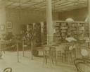
| Date: | 1896 |
|---|---|
| Description: | Interior view of the Eau Claire Public Library. Tables and bookshelves in the public library reading room. |
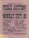
| Date: | 1882 |
|---|---|
| Description: | Broadside advertising a public auction at the estate of Olaus Haagenson. |
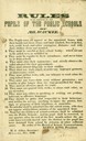
| Date: | 1846 |
|---|---|
| Description: | "Rules to be observed by the pupils of public schools of Milwaukee." |
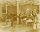
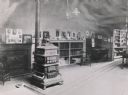
| Date: | 1896 |
|---|---|
| Description: | Bookshelves and desks within the Eau Claire Public Library Reading Room. |

| Date: | 1854 |
|---|---|
| Description: | A sketch of the public surveys of Wisconsin and territory of Minnesota. |
| Date: | 1887 |
|---|---|
| Description: | Interior view of the First Public Library. It was located over Pondee Grocery Store on College Avenue. |
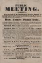
| Date: | 09 1838 |
|---|---|
| Description: | A public notice of a meeting that nominated Hon. James Duane Doty for Delegate to Congress for this Territory. Other names on document; Hon. Gilbert Knapp,... |
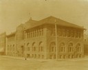
| Date: | 1896 |
|---|---|
| Description: | Corner view from intersection towards the Ingram block, which contained the public library. |

| Date: | 1850 |
|---|---|
| Description: | This map of Cassville shows plat of the town, roads, landings and public wharfs and the Mississippi River. |

| Date: | 05 31 1860 |
|---|---|
| Description: | A broadside titled, "A Valuable Estate In Rockbridge County, VA., For Sale At Public Auction," regarding the sale of Joseph Trevey's estate. |

| Date: | 1874 |
|---|---|
| Description: | Bird's-eye map of Lodi, with inset of Public School. Includes index of churches and points of interest. |

| Date: | 1850 |
|---|---|
| Description: | This map of Geneva shows lots and acreages, reserved land, and public squares. Streets and Lake Geneva are labeled. The map includes manuscript annotations... |
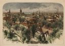
| Date: | 1874 |
|---|---|
| Description: | Bird's-eye view of Milwaukee looking southwest toward the county courthouse under construction in the public square west of St. John's Cathedral. |

| Date: | 1882 |
|---|---|
| Description: | This map is ink and watercolor on paper and shows numbered plots, the public square, streets, Lake St. Croix and the Mississippi River. |
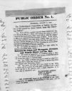
| Date: | 08 31 1862 |
|---|---|
| Description: | Photograph of a printed broadside, Public Order No. 1., issued by The Committee of Safety. The first order appears to be addressing some kind of dangerous ... |

| Date: | 1878 |
|---|---|
| Description: | This bird’s-eye-view map of Barton is indexed for parochial and public schools, churches, a convent, the railroad depot, and the post office. |

| Date: | 01 01 1856 |
|---|---|
| Description: | This map is mounted on cloth and shows lots, as well as location of the public square and college. Streets are labeled as is the Wisconsin River. |
If you didn't find the material you searched for, our Library Reference Staff can help.
Call our reference desk at 608-264-6535 or email us at: