 Search: public
Filter: Subject of bays
Search: public
Filter: Subject of bays

| Date: | 1960 |
|---|---|
| Description: | This map is a facsimile of a 1829 map and shows private land claims, landowners within military reserve boundaries, sawmill, Fort Howard, public barns, bri... |

| Date: | |
|---|---|
| Description: | View from shoreline looking out towards the public beach with several bathers. Diving platforms are out in the bay. Caption reads: "Fish Creek, Wis. The Ba... |

| Date: | 1906 |
|---|---|
| Description: | This map shows streets, railroads, land use, public buildings, commercial businesses, and the Menominee River. Depths are shown by gradient tints and sound... |

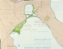
| Date: | 1960 |
|---|---|
| Description: | This map shows public boat ramps, parks, highways, beaches, bluffs, Green Bay, Garrett Bay, Europe Bay and Lake, Rowley's Bay and Ellison Bay. The map incl... |

| Date: | 1914 |
|---|---|
| Description: | Includes index of University of Wisconsin buildings, churches, and public buildings. Top of Map reads: '"GET A SQUARE DEAL" AT THE COLLEGE BOOK STORE SHOWN... |
| Date: | 1967 |
|---|---|
| Description: | Schematic Master Plan for the City of Madison, Wisconsin. William Wesley Peters, Architect • The Frank Lloyd Wright Foundation. |
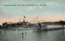
| Date: | 1918 |
|---|---|
| Description: | The pavilion and bath house at Bay View Beach. Bathers are walking in the shallow water in the foreground. Caption reads: "Pavilion and Bath House, Bay Vie... |

| Date: | 1894 |
|---|---|
| Description: | This map shows lot and block numbers, railroads, street car tracks, sewers, water mains, gas mains, paved streets, land owned by the Land & River Improveme... |

| Date: | 1950 |
|---|---|
| Description: | Map is ink and color on a photocopied base map. Map shows district limits, proposed future limits, and names of land owners. Base map, by A.A. Porath, show... |

| Date: | 1989 |
|---|---|
| Description: | This color coded map shows the various rivers, lakes, bays, and islands that make up the harbor. It includes an index of industries (maritime and non-marit... |
If you didn't find the material you searched for, our Library Reference Staff can help.
Call our reference desk at 608-264-6535 or email us at: