 Search: public
Filter: Subject of boats and boating
Search: public
Filter: Subject of boats and boating

| Date: | 1959 |
|---|---|
| Description: | This map shows public access sites, public beaches and parks, other public shorelines, boat liveries, public hunting and fishing grounds, railroads, roads,... |
| Date: | |
|---|---|
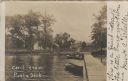
| Description: | Photographic postcard from the end of the public dock looking inland towards buildings on the shoreline. Caption reads: "Cecil from Public Dock." |
| Date: | 1905 |
|---|---|
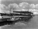
| Description: | View across water toward a public steamboat landing. |

| Date: | 2000 |
|---|---|
| Description: | This map shows Wisconsin Public Service Corporation property, special regulation areas, public boat landings, roads, parks, and other recreation areas. Ins... |

| Date: | 1990 |
|---|---|
| Description: | This map shows various types of trails, boat landings, canoe areas, public beaches, picnic areas, campgrounds, golf courses, public tennis courts, and othe... |

| Date: | 1870 |
|---|---|
| Description: | Bird's-eye map of Hudson, with insets of Court House and Public School. |

| Date: | 1960 |
|---|---|
| Description: | This map shows improved town roads, federal highways, county highways, public boat access, public hunting areas, railroads, and lakes in the area around th... |

| Date: | 1969 |
|---|---|
| Description: | This map shows businesses, resorts, roads, public boat landings, schools, cemeteries, and location of fish and game. An inset map reads: Continuation along... |

| Date: | 1955 |
|---|---|
| Description: | A motorboat on Lake Neshonoc is speeding toward the public landing, where there is a car parked and a small group of people has gathered. A man in a swimmi... |

| Date: | 1980 |
|---|---|
| Description: | This map shows schools, hotels, stations, roads, railroads, reefs, and public buildings. The upper right corner includes "A Summer and Winter Guide for Spo... |
| Date: | 1942 |
|---|---|
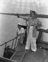
| Description: | Olive Brooks, Army Division Engineer Public Relations with her .45 on the "Dolphin", Chucunaque River, Panama. She is pointing her gun out towards the rive... |

| Date: | 1960 |
|---|---|
| Description: | This map shows public boat ramps, parks, highways, beaches, bluffs, Green Bay, Garrett Bay, Europe Bay and Lake, Rowley's Bay and Ellison Bay. The map incl... |

| Date: | 1905 |
|---|---|
| Description: | This map shows a plat of the city, local streets, railroads, public buildings, local businesses, and parts of the Manitowoc River and Lake Michigan. Relief... |

| Date: | 1925 |
|---|---|
| Description: | This map shows a plat of the city, local streets, railroads, public buildings, local businesses, and parts of the Manitowoc River and Lake Michigan. Relief... |

| Date: | |
|---|---|
| Description: | A bathing beach on an island near a bridge, with people in the water and on the beach within an enclosed area. A canoe and rowboat are pulled up on the sho... |
| Date: | 07 1946 |
|---|---|
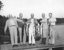
| Description: | Dwight D. Eisenhower, fishing with his brothers on Wisconsin Lake, proudly exhibit Muskies and one Northern Pike. |

| Date: | 1902 |
|---|---|
| Description: | This map is a chart of Milwaukee Harbor that displays local streets, bridges, roads, railroads, public buildings, businesses, factories, dry docks, parks, ... |

| Date: | 1994 |
|---|---|
| Description: | This map shows historical sites, picnic grounds, public boat landings, canoe and motor boat trips, and resort locations. The left margin of the map include... |
| Date: | |
|---|---|
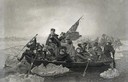
| Description: | Engraving of George Washington and his troops rowing across an icy Delaware River to attack the British, from the painting by E. Leutze. |

| Date: | |
|---|---|
| Description: | Colorized postcard view from pier towards a large recreation building. The excursion boat "Miss Geneva" is under an awning on the right. Caption reads: "Mu... |
If you didn't find the material you searched for, our Library Reference Staff can help.
Call our reference desk at 608-264-6535 or email us at: